Ushuku (Kagoshima-shi)
| Ushuku | |
|---|---|
| — 町丁 — | |
| | |
 Ushuku | |
| A coordinate: 31°32'N 37.6 seconds 130°32'E 18.2 seconds / 31.543778 degrees N 130.538389 degrees E | |
| Country | |
| The metropolis and districts | |
| Cities, towns and villages | |
| Area | Center area |
| District | Kamoike district |
| Population (as of 2013 (2013) October 1) | |
| - 計 | 14,114 people |
| Equal time obi | JST (UTC +9) |
| Zip code | 890-0073 |
Ushuku (thin Usuki) is a name of a street of Kagoshima-shi, Kagoshima. Mt. old valley county Taniyama volost Ushuku-mura, Kagoshima-gun Kagoshima neighboring villages Ushuku-mura, 鹿児島郡中郡宇村大字宇宿, Usuki, Kagoshima-shi-cho. There is 9, Ushuku from 1, Ushuku and carries out house indication in the whole area from 1, Ushuku to 9, Ushuku. As for the population, 14,000 people, the number of the households are 6,442 households (as of March 1, 2012); [1]. The zip code is 890-0073 from 1, Ushuku to 9, Ushuku.
Table of contents
Geography
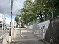
It is located in the lower basin from the basin in the central part of Kagoshima-shi, Wakita River. I run west from Hiroki, Minamikorimotocho, the south in the north of the town area, and Higashitaniyama, Toukaicho, Komatsubara contact each south, and, Sakuragaoka, Nishimurasakibarucho, Murasakibaru, Hinodecho, Minamishincho contact with Chuokoushinmachi that assumes the artificial island called the Malin port in the east town area east west Koyou, Obaracho, and 2, Ushuku is bound together with Malin port Kagoshima by Malin port Ohashi constituting a part of the Kagoshima Port harborside road.
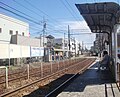
Kagoshima prefectural road 217 county former Kagoshima Port line (a part of the industrial road), National highway No. 225, Kagoshima streetcar Taniyama line, Kyushu Railway Co. Ibusuki Makurazaki Line go along the eastern part of the town area parallel to the north and south.
Nikenchaya streetcar stop, 1, Ushuku streetcar stop, Wakita streetcar stop are established on Kagoshima streetcar, and Usuki Station is established to Ibusuki Makurazaki Line. In addition, in late years there is the Ushuku Hiroki line of the city planning road going along the town area to the east and west;; Ushuku middle, Hiroki district land readjustment business is performed along the line [2].
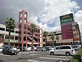
In the educational facility, Kagoshima City Ushuku elementary school is at 4, Ushuku. In addition, as for 1:00 period, the Ushuku mall in the town was losing vigor by a series of branches of the large commercial facilities such as ion Kagoshima shopping centers (existing Aeon Mall Kagoshima), but appointed [3] is returning vigor to "77 selections of malls to try hard newly" by the "local spirit reproduction business" and Small and Medium Enterprise Agency by the Cabinet Secretariat in 2009 again.
River
- Wakita River
- The second grade river [2] which flows through the central part of the town area to the east and west. The maintenance of the dike is carried out by Ushuku midtown land readjustment business.
History
Establishment and Middle Ages of Ushuku
There was the place name called Ushuku among vanity, Mt. Satsuma country valley counties from Kamakura period. It is thought that it is a first interview of the place name of Ushuku that the grants from the Tadashi Yamada truth of Kenji two years to Naohisa show with "たにやまのこほりのうちうすくのこう" [4].
In addition, the record that a rice field in the ground is performed oblation of by 福昌寺 remains, but it is said that prohibition of the glebe was started later by Motohisa Shimazu.
Early modern Ushuku
It was old and belonged to the Yamada volost among Mt. valley county Taniyama volost (outside castle) for Edo period. The total output of a village was 755 石余 in "Tenpo era district tax register" in 1,530 石余, "former high former territory" [4].
I changed the position from the Mt. valley county to the Kagoshima-gun Kagoshima neighboring villages from (1871) in 1871. Paths of Yamakawa (current National highway No. 225), Italy product street went in the village area.
I am until Kagoshima-shi admission by the municipality organization enforcement
中郡宇村 started with municipality organization having been enforced (1889) on April 1 in 1889 from Nakamura, county Motomura, an area of Ushuku-mura in previous Kagoshima neighboring villages, and Ushuku-mura of Edo period became larger section of a village "Ushuku" of 中郡宇村 [5].
The whole area of larger section of a village Ushuku became name of a street "Ushuku-cho" of Kagoshima-shi with the whole area of 中郡宇村 having been incorporated into Kagoshima-shi (1934) on August 1 in 1934 [5].
Name of a street rearranging by development and the land readjustment of neighboring residential areas
The residential area development on the neighboring plateaus including the Murasakibaru plateau came to be carried out flourishingly, and a part of Ushuku-cho was divided with it at 7, Murasakibaru from Hinode-cho, 1, Murasakibaru in (1970) in 1970. In addition, in the same year, 1, Ushuku, 2, Ushuku, 3, Ushuku were established than a part of Ushuku-cho and a part of Koorimotocho [5].
7, Sakuragaoka was established from 1, Sakuragaoka from the area of the Sakuragaoka housing complex in (1978) in 1978, and a part of Ushuku-cho was incorporated into Sakuragaoka [6], and Nishimurasakibarucho was divided from an area of 梶原迫団地 of Usukicho in (1982) in 1982 [7]. 4, Ushuku and 5, Ushuku were founded than a part of Ushuku-cho in (1990) in 1990, and a part was incorporated into Nishimurasakibarucho, 3, Murasakibaru, Hinode-cho [8]. A part of Ushuku-cho was incorporated into 6, Sakuragaoka (1996) on October 28 in 1996 [9], and a part of Ushuku-cho was incorporated into a part of 3, Murasakibaru in (1999) in 1999 [10].
Land readjustment business for the purpose of the traffic jam measures of the old road of the municipal road Ushuku Hiroki line via the central part of the town area and the improvement of the house environment was started construction of from about 1991 [11]. I incorporated a part of Ushuku-cho into 4, Ushuku and 5, Ushuku (2010) on February 15 in 2010 and founded 6, Ushuku and 7, Ushuku [12].
I founded 8, Ushuku, 9, Ushuku and incorporated a part of Ushuku-cho into 7, Sakuragaoka, 5, Murasakibaru, and 2, Koyou was founded than a part (2011) on February 14 in 2011 by a part of Ushuku-cho [13]. It was a part of Hiroki 2 and of Hiroki 3 founded on the same day (2013) 9, Ushuku, other areas 6, Ushuku, pan ケ Uto district 永仮地区 in Ushuku-cho to remain in on February 18 2013. All of Ushuku-cho became some Ushuku or Hiroki, and "Ushuku-cho" in this way became extinct [14].
Chronological table
- It became the position change in Kagoshima-gun from the Mt. - valley county in 1871 and became 1 village of Kagoshima neighboring villages.
- It becomes 鹿児島郡中郡宇村 with Nakamura, county Motomura by - municipality organization enforcement in 1889 and becomes larger section of a village Ushuku.
- It becomes Usuki, Kagoshima-shi-cho with - 中郡宇村 having been incorporated into Kagoshima-shi in 1934.
- A part of - Ushuku-cho becomes 7, Murasakibaru, Hinode-cho from 1, Murasakibaru in 1978, and 1, Ushuku, 2, Ushuku, 3, Ushuku are established.
- A part of - Ushuku-cho becomes Nishimurasakibarucho in 1982.
- 4, Ushuku, 5, Ushuku are established than a part of - Ushuku-cho in 1990 and incorporate a part of Ushuku-cho into Nishimurasakibarucho, 3, Murasakibaru, Hinode-cho.
- I launch - Ushuku middle, Hiroki district land readjustment business in 1991.
- A part of - Ushuku-cho is incorporated into 6, Sakuragaoka in 1996.
- A part of - Ushuku-cho is admitted into 3, Murasakibaru in 1999.
- 6, Ushuku, 7, Ushuku are established than a part of - Ushuku-cho in 2010 and incorporate a part of Ushuku-cho into 4, Ushuku, 5, Ushuku.
- 8, Ushuku, 9, Ushuku, 2, Koyou are established than a part of - Ushuku-cho in 2011 and incorporate a part of Ushuku-cho into 7, Sakuragaoka, 5, Murasakibaru.
- I incorporated residue of - Ushuku-cho into 6, Ushuku, 9, Ushuku, Hiroki 2, Hiroki 3 in 2013, and "Ushuku-cho" as the name of a street was in this way abolished.
Change of the town area
| After division enforcement | Division enforcement year | It is before division enforcement |
|---|---|---|
| Hinode-cho | 1970 (1970) | A part of Ushuku-cho |
| It is 7, Murasakibaru from 1, Murasakibaru | ||
| It is 3, Ushuku from 1, Ushuku | A part of Ushuku-cho and Koorimotocho | |
| It is a part of 7, Sakuragaoka from 1, Sakuragaoka | 1978(Showa53) | A part of Ushuku-cho |
| Nishimurasakibarucho | 1982(Showa57) | |
| 4, Ushuku and 5, Ushuku | 1990(HeiseiTwo years) | |
| A part of Nishimurasakibarucho | ||
| A part of 3, Murasakibaru | ||
| A part of Hinode-cho | ||
| A part of 6, Sakuragaoka | 1996(HeiseiEight years) | |
| A part of 3, Murasakibaru | It is March 29 (1999) for 1,999 years | |
| A part of 4, Ushuku and 5 | It is February 15 (2010) for 2,010 years | |
| 6, Ushuku, 7 | ||
| 8, Ushuku, 9 | It is February 14 (2011) for 2,011 years | |
| 2, Koyou | ||
| 5, Murasakibaru | ||
| 7, Sakuragaoka | ||
| A part of 6, Ushuku | It is February 18 (2013) for 2,013 years | A part (永仮地区) of Ushuku-cho |
| A part of 9, Ushuku | A part (pan ケ Uto district) of Ushuku-cho | |
| A part of Hiroki 2 | Ushuku-cho, a part of Tagami-machi | |
| Hiroki 3 |
Facilities
- The community
-
- Kagoshima social insurance medical treatment reward payment fund
- Education
- Buddhist temple and Shinto shrine
- Commerce
-
- オプシアミスミ
- Square lacing braid Ushuku, Kagoshima
- Round One Ushuku, Kagoshima store
- Sagawa Kyubin Kagoshima store
The number of the households, population
| Town, 丁名 | The number of the households | Population |
|---|---|---|
| 1, Ushuku | 1,516 | 2,961 |
| 2, Ushuku | 494 | 1,008 |
| 3, Ushuku | 1,172 | 2,206 |
| 4, Ushuku | 570 | 1,215 |
| 5, Ushuku | 801 | 1,731 |
| 6, Ushuku | 629 | 1,565 |
| 7, Ushuku | 515 | 1,364 |
| 8, Ushuku | 229 | 624 |
| 9, Ushuku | 317 | 856 |
| Ushuku-cho | 199 | 470 |
| 計 | 6,442 | 14,000 |
School district of the elementary and junior high school
When I go to the municipal elementary and junior high school, the school district (precinct) is as follows [15].
| 町丁 | Turn, address | Elementary school | Junior high school |
|---|---|---|---|
| 1, Ushuku | The whole area | Kagoshima City Ushuku elementary school | School in the Kagoshima City south |
| 2, Ushuku | The whole area | ||
| 3, Ushuku | The whole area | ||
| 4, Ushuku | The whole area | ||
| 5, Ushuku | The whole area | ||
| 6, Ushuku | It is the 14th, a part of the 15,16 turn from the first | ||
| The whole area except the above | Kagoshima City Koyou elementary school | Kagoshima City west Murasakibaru junior high school | |
| 7, Ushuku | It is the 29th from the eighth, the 26th from the first | Kagoshima City Ushuku elementary school | School in the Kagoshima City south |
| It is the 25th from the ninth | Kagoshima City Koyou elementary school | Kagoshima City west Murasakibaru junior high school | |
| 8, Ushuku | It is the 15th, a part of the 19th ,16,17 turn from the first | ||
| For each one copy of the 16,17,18 turn | Kagoshima City Murasakibaru junior high school | ||
| The 18th part | Kagoshima City Hiroki Elementary School | ||
| The 20th, the 18th part | Kagoshima City west Murasakibaru elementary school | Kagoshima City west Murasakibaru junior high school | |
| 9, Ushuku | The whole area | Kagoshima City Koyou elementary school |
Traffic
Railroad

Road
- National highway
- Prefectural road
-
- Kagoshima prefectural road 217 county former Kagoshima Port line (industrial road)
- Municipal road
-
- City planning road Ushuku Hiroki line
Bus
There is などの bus stop.
Footnote
- I read it on ^ a b statistics information - Kagoshima-shi official web site April 15, 2011.
- ^ a b Ushuku midtown - Kagoshima-shi December 5, 2011 reading.
- I read "mall 77 selections Kyushu, Okinawa (Fukuoka, Saga, Nagasaki, Kumamoto, Oita, Miyazaki, Kagoshima, Okinawa) of the ^ whole country doing its best newly" (PDF) on p.149 - Small and Medium Enterprise Agency May 22, 2012.
- ^ a b "Tsunogawa Japan place name Dictionary 46 Kagoshima" p.131
- ^ a b c "Tsunogawa Japan place name Dictionary 46 Kagoshima" Kadokawa Shoten p.132
- ^ "Tsunogawa Japan place name Dictionary 46 Kagoshima" Kadokawa Shoten p.306
- Open space 1982 of the ^ Kagoshima citizen (November, 1982 issue) the 186th (PDF) - Kagoshima-shi (Kagoshima-shi public information digital archive) April 13, 2012 reading.
- Open space 1990 of the ^ Kagoshima citizen (November, 1990 issue) the 282nd (PDF) - Kagoshima-shi (Kagoshima-shi public information digital archive) April 13, 2012 reading.
- ^ 1996 Kagoshima notification 1518th (setting of the area of the town and change, 2 所収 of October 28, 1996 date Kagoshima bulletin 1136th)
- ^ 1999 Kagoshima notification 466th (change of the area of the town, March 23, 1999 date Kagoshima bulletin 1456th 号所収)
- 17 ^ a b "Minami Nihon Shimbun" March 13, 2012 dates (373 wide town Ushuku newspaper west edition)
- I read it on ^ Ushuku middle, Hiroki district (the first) house indication enforcement - Kagoshima-shi December 5, 2011.
- I read it about the ^ Ushuku middle, Hiroki district (second period) house indication enforcement on - Kagoshima-shi HP February 8, 2011.
- I read it on ^ Ushuku middle, Hiroki district (third period) house indication enforcement - Kagoshima-shi February 17, 2013.
- ^ "precinct list of the elementary and junior high school." Kagoshima-shi government office. July 29, 2011 reading.
Allied item
- Ushuku (vagueness evasion page)
- List of place name of the Kyushu district difficult to read
Outside link
This article is taken from the Japanese Wikipedia Ushuku (Kagoshima-shi)
This article is distributed by cc-by-sa or GFDL license in accordance with the provisions of Wikipedia.
In addition, Tranpedia is simply not responsible for any show is only by translating the writings of foreign licenses that are compatible with CC-BY-SA license information.
0 개의 댓글:
댓글 쓰기