Shiga slope Pass
The mountain pass where the Shiga slope Pass (しがさかとうげ) links Kanna-machi, Tano-gun, Gunma to Ogano-machi, Chichibu-gun, Saitama. Altitude is 780m. Shiga Hill tunnel of National highway No. 299 goes in the neighborhood of top of the mountain pass and becomes the prefectural border in a tunnel.
In addition, there is the divergence with the Kanayama Shiga Hill forest road on the tunnel Saitama side entrance this side and can go to Chichibu municipal road Otaki main line Route 17 (old Nakatsugawa forest road) knowing Kawakami-mura, Minamisaku-gun, Nagano via the Nakatsugawa, Chichibu-shi, Saitama area from there.
-

Saitama side (November, 2005) of the Shiga Hill tunnel
-
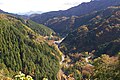
I see the Chichibu area from Shiga slope Pass (November, 2005)
-
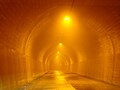
The Shiga Hill tunnel inside (July, 2003)
Neighboring
- Mt. Futago (rock peak of 1,166m above sea level)
- Ripples rock (fossil of the trace of the seaside wave of the さざなみいわ Cretaceous and the footprint of the dinosaur)
Allied item

This article is taken from the Japanese Wikipedia Shiga slope Pass
This article is distributed by cc-by-sa or GFDL license in accordance with the provisions of Wikipedia.
In addition, Tranpedia is simply not responsible for any show is only by translating the writings of foreign licenses that are compatible with CC-BY-SA license information.
0 개의 댓글:
댓글 쓰기