Tsurumai (Ichihara-shi)
| | There are plural problems with this article. Please cooperate with improvement and the discussion in the notebook page.
|
| Tsurumai | |
|---|---|
| — 町丁 — | |
 Tsurumai | |
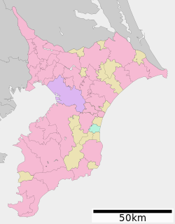
| A coordinate: 35°22'N 42.5 seconds 140°11'E 14.3 seconds / 35.378472 degrees N 140.187306 degrees E | |
| Country | |
| The metropolis and districts | |
| Cities, towns and villages | |
| As of a population of November, 2016 | |
| - 計 | 1,151 [1] people |
| Equal time obi | JST (UTC +9) |
| Zip code | 290-0512[2] |
| Number plate | Sodegaura |
Tsurumai (I will not have it cramped) is the place name of Ichihara-shi, Chiba. The zip code is 290-0512.
Table of contents
Summary
An enclave is to the west across Ishikawa.
The north catches Mizusawa, Mizusawa in the south from Okuno, the east, and there is Chonan-machi, and Ishikawa is to the west.
Education
It is the school district of the Ichihara City Tsurumai Elementary School, Ichihara City south total junior high school. [3]
Traffic
Station
Unavailable
Bus
| System | The way ground | Destination |
|---|---|---|
| Cow 06 | Tsurumai, Heizo | Ootaki garage line |
| Cow 07 | Tsurumai station | Going to Tsurumai |
| 茂 30, 茂 45 | Osanami Office | Going to Mobara Station south exit |
| Cow 04 | Tao, Yuhara | Going to Satomi Station |
| Cow 04, cow 06, 07, 茂 30 | In front of south total junior high school | Going to Ushiku Station |
| 茂 30 | Ikenotani field | Going to Tsurumai Station |
Road
Facilities
- Chiba Prefectural Tsurumai Sakuragaoka high school
- Tsurumai nursing technical school
- Chiba National Cardiovascular Center
- Tsurumai dental clinic
- Kasamori Tsurumai nature park
Source
This article is taken from the Japanese Wikipedia Tsurumai (Ichihara-shi)
This article is distributed by cc-by-sa or GFDL license in accordance with the provisions of Wikipedia.
In addition, Tranpedia is simply not responsible for any show is only by translating the writings of foreign licenses that are compatible with CC-BY-SA license information.
0 개의 댓글:
댓글 쓰기