Mt. rabbit (Nagano)
| Mt. rabbit | ||
|---|---|---|
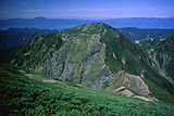
 Mt. rabbit covered to a creeping pine to expect from the Mt. small rabbit | ||
| Altitude | 2,818 [1] m | |
| The location | Iida-shi, Nagano, ShizuokaShizuoka-shiAoi-ku | |
| Position | 35°25'43" N A 138°7'16" E coordinate: 35°25'43" N 138°7'16" E [1] | |
| Mountain range | Akaishi Mountains (the Southern Alps) | |
| Kind | Fold upheaval | |
 | ||
Mt. rabbit (only as for the rabbit) is a mountain of 2,818m above sea level to be located in the border of Iida-shi, Nagano and Aoi-ku, Shizuoka-shi in southern Akaishi Mountains (the Southern Alps). It is in Minami Alps National Park [2], and there is Mt. small rabbit (2,738m above sea level) in the north side immediately.
Table of contents
Summary
In the main ridgeline of Akaishi Mountains, the ridge which lengthened in west-northwest from Hijiridake is located at the point to bend in north by northeast. Height of average Maruyama, Mt. Osawa and Akaishidake range to the north of the Mt. rabbit. With the triangulation point (as for the point name Mt. rabbit, 2799.33m above sea level) third-class on the Nagano side that the summit of Mt. rabbit extends over Shizuoka side and the Nagano side, but came off in a prefectural border ridgeline a little to the west [3]. From the valley of the Toyama River of the branch of Western Tenryugawa, I can expect a figure of a mountain of the Mt. magnificent rabbit.
Environmental
The mountaintop neighborhood becomes the warren of the alpine plant in the habitat of the snow grouse in a creeping pine zone of the timberline. The south slope becomes the collapse place; and with the exposure place of the chart (ラジオラリア 盤岩) red on the southwestern slope of Hijiridake [4]. Summer has many precipitations. The mountaintop part may lie until the end of May. Until about the beginning of June, there is remaining snow in the mountain trail of the mountaintop part. When November begins, the mountaintop part becomes the full-scale winter mountain.
Feeding damage of the deer
The populations of the deer increase under the influence of decrease or the global warming of the hunter, and the skin of conifer of the plantation of the hillside is eaten, and the feeding damage of the deer that alpine plants are eaten up except the toxic thing of the alpine belt produces even neighboring Southern Alps Nanbu. A protection fence was installed in the area of approximately 1,100 m² to protect the warren of the alpine plant which was the bait of the snow grouse of the neighborhood of mountaintop from feeding damage of the sika from August 28, 2010 through 30th [5]. In the neighboring creeping pines zone, alpine plants such as Thymus quinquecostatus, シロバナタカネビランジ, Takane gypsy rose, the Pedicularis Chamissonis are seen.
Mountain climbing


There is a mountain trail on Southern Alps main ridgeline, and there is not the public mountain trail climbing the direct mountaintop elsewhere. Therefore, it is climbed at the time of Southern Alps mountain traversing, and there are few examples reached the summit of only for the purpose of this mountain. From the mountaintop, there is the 360-degree view including the Northern Alps to the mountains, the west of the neighboring Southern Alps northwest the center Alps.
Mountain trail
- Southern Alps mountain traversing road
- - Mt. Mt. Mt. Mt. Mt. Mt. height of Mt. Akaishidake - Osawa - average Maruyama - small rabbit - rabbit - rabbit refuge hut - Hijiridake - common monk - Saint flat - south - Kamigouchi -
- The vertical course of the main ridgeline of the Southern Alps passes the mountaintop.
- Route (Nagano side) from the flight ヶ island
- Mt. Mt. Mt. flight ヶ island (Saint light hut) - Wataru Nishizawa - thistle field - Saint flat - common monk - Hijiridake - rabbit refuge hut - rabbit
- With the mountain trail from the western (Nagano side) convenience ヶ island (news an island) [6]. Part goes along the ruins of the Toyama forest railway [7]. Former Wataru Nishizawa (にしさわど) has a walking point from the flight ヶ island, and basket handing over for the baggage transportation that used a pulley is installed.
- Route (Nagano side) of the しらびそ mountain pass
- しらびそ mountain pass - (forest road) - Mt. Mt. height of Mt. Wataru Osawa descendant - Wataru Osawa (north crotch swamp walking point) - Wataru Osawa mountain cottage - Japanese larch mountain pass - Osawa - average Maruyama - small rabbit - rabbit
- There are few users, and the mountain trail is not maintained. A basket ferry for the baggage transportation is installed in Wataru Osawa.
- Route (Shizuoka side) from the Saint swamp
- Mt. Mt. Mt. Higashimata forest road (Saint Sawanobori Yamaguchi) - Saint swamp suspension bridge - Saint flat (Saint flat hut) - common monk - Hijiridake - rabbit refuge hut - rabbit
- The mountain trail of the Saint swamp links Saint flat を to the Akaishi dam of Oi River of the east side (Shizuoka side) [8].
Neighboring mountain hut
On the starting point of a mountain climb and the ridgeline with a mountain hut and the camping appointed place [4] [9]. I perform manned business during some periods in a mountain climbing season. Mt. rabbit refuge hut is to mountaintop approximately 100m east underneath. Floor and a door were broken and went to ruin, but repair was carried out as natural environments maintenance business in (2009) in 2009 [10].
| Name | The location | Altitude (m) | From the Mt. rabbit Direction and distance (km) | The accommodation The number of people | Camping Appointed place | Remarks |
|---|---|---|---|---|---|---|
| Highland しらびそ | Shirabiso Kogen | 1,918 | West 8.4 | 88 | Auto camp facilities | The public accommodations |
| Sawarajima lodge | Oi River right bank Sawarajima | 1,123 | East 7.8 | 150 | 50 tents | Tokai Forest [11] |
| Wataru Osawa mountain cottage | It is east 400m for Wataru Osawa | 1,247 | Northwest 4.9 | 15 | Iida-shi, deterioration | |
| Akaishidake refuge hut | The Akaishidake mountaintop south underneath | 2,990 | Northeast 4.8 | 30 | Shizuoka is under prefectural management | |
| 100 ken of sinus mountain lodges | The saddle south with Akaishidake and the Mt. Osawa | 2,430 | North 2.5 | 60 | 20 tents | Shizuoka municipal management |
| Mt. rabbit refuge hut | The east right under the Mt. rabbit mountaintop | 2,740 | East 0.1 | 8 | Iida-shi | |
| Saint flat hut | A Saint swamp source part Saint; is flat | 2,260 | Southwest 5.5 | 120 | 50 tents | Managed by Shizuoka [12] |
| Saint light hut | Flight ヶ island | 970 | Southwest 6.0 | 24 | 40 tents | Hijiridake starting point of a mountain climb [13] of the Nagano side |
Water hole
- Running water of Okuaka Ishizawa under the east side of the col with Mt. small rabbit and the Mt. rabbit may be available.
- The water of a certain swamp is available beside Hijiridake hut. When I dry up, it is often available more in the down stream.
- Thin Iwashimizu may appear on the Shinshu side (the west) of the ridgeline saddle of the lower part of small Hijiridake. A tool to draw the water such as cups is necessary.
- At a walking point of Wataru Osawa and Wataru Nishizawa, the water of the swamp is available.
- The water supply facilities of the Sawarajima lodge are available.
Geography
The southern main ridgeline of Akaishi Mountains (the Southern Alps) is located above. A ridgeline extends to the Mt. Osawa in the north side, and a ridgeline extends to Hijiridake on the east side. In addition, a remarkable branch ridge spreads to the Mt. Kasamatsu of western 立俣山 (2,366m) and the southwestern side (1,976m) [4].
Neighboring mountain

Mt. Arakawadake - Akaishidake - rabbit - Hijiridake - (Mount Fuji) - Mt. Kamigouchi

| Figure of a mountain | Name | Altitude (m) | Triangulation point class Threshold name [3] | From the Mt. rabbit Direction and distance (km) | Remarks |
|---|---|---|---|---|---|
 | Akaishidake | 3,120.06 | The first prize "Akaishidake" | Northeast 4.9 | The highest peak of the first-class triangulation point 100 famous mountains in Japan |
 | Mt. Osawa | 2,819.36 | The third prize "Mt. Osawa" | North 2.3 | 双耳峰 |
 | Height of average Maruyama | 2,807 | North 1.6 | ||
 | Mt. small rabbit | 2,738 | North 0.9 | ||
 | Mt. rabbit | 2,818 | (the third prize) "Mt. rabbit" (2799.33m) | 0 | Mt. rabbit refuge hut |
 | Hijiridake | 3,013 | East 1.8 | 100 famous mountains in Japan | |
 | Mt. Kamigouchi | 2,802.95 | The second prize "Mt. Kamigouchi" | Southeast 5.2 | 200 famous mountains in Japan |
River of the source
The river becoming the following source flows through the Pacific [4].
- Okuaka Ishizawa (branch of Oi River)
- Kitazawa, rabbit sinus, Nishizawa (branch of the Toyama River of the Tenryugawa water system)
Traffic, access
Nagano side (flight ヶ island)
- In the case of use of public transport, there is not public transport near the flight ヶ island of the Hijiridake starting point of a mountain climb. After getting off at Iida Station of JR Iida Line or Hiraoka Station, and using a taxi, or having changed to a route bus from there, I will use a taxi.
- In the case of use of car, a large tree interchange of the three rules of perspective in landscape south sincerity Expressway is the nearest interchange. A forked tool tunnel of National highway No. 474 is available. There is the parking lot for exclusive use of the mountaineer in the Saint light hut.
Shizuoka side (畑薙第一 dam)
- In the case of use of public transport, the bus to 畑薙第一 dams is available from Shizuoka Station.
- In the case of use of car, Shizuoka Interchange of the Tomei Expressway is the nearest interchange. There is a gate in the point of the 畑薙第一 dam, and the general vehicle cannot run in the Higashimata forest road of there. I will use an appointed parking lot. In addition, the prefectural road to the 畑薙第一 dam may be closed to traffic by landslides.
Scenery of the Mt. rabbit and fine-view
 |  |  |  |
| I see it from Hijiridake Collapse place and Mts. Kiso of the rabbit Gakunan surface | I see it from the Hijiridake area Mt. rabbit | I see it from small Hijiridake Mt. rabbit after the snowcap | I see it from the Mt. rabbit The ridgeline which leads from the saddle to Hijiridake |
Allied bookm
- In "Shinnihon mountains" Japan mountaineering club, Nakanishi-ya publication, November, 2005, it is p.1064. ISBN 4779500001。
- "Alpen guide 10 Southern Alps" Yama-Kei Publishers 〈 mountain Kay Alpen guide 〉, June, 2010. ISBN 9784635013581。
Footnote
- ^ a b "Main mountains altitude (the mountains of Nagano) of Japan". Geographical Survey Institute. May 12, 2011 reading.
- ^ "park area summary of Minami Alps National Park." The Ministry of the Environment natural environments station. May 12, 2011 reading.
- ^ a b "I read it, and threshold result gives a service". Geographical Survey Institute. May 12, 2011 reading.
- 〉, March, 2011 for ^ a b c d "Shiomi, Akaishi, Hijiridake" Shobunsha 〈 mountain and plateau map 2,011 years for. ISBN 978-398,757,821.
- ^ "protects a South African national park from feeding damage of the sika". South Shinshu newspaper (September 10, 2010). May 12, 2011 reading.
- In ^ "mountains of revised edition Nagano" Yama-Kei Publishers 〈 new division into prefectures mountain guide 〉, January, 2010, it is pp.150-152. ISBN 9784635023658。
- The ^ "feature of the forest railway left in the present age." Toyama volost tourist association. May 10, 2011 reading.
- In ^ "mountains of revised edition Shizuoka" Yama-Kei Publishers 〈 new division into prefectures mountain guide 〉, December, 2009, it is pp.55-57. ISBN 9784635023719。
- In ^ "mountain and 溪谷 January, 2011 issue appendix" (convenience notebook 2011 of the mountain) Yama-Kei Publishers, December, 2010, it is pp.134-139, ASIN B004DPEH6G.
- ^ "Environmental white paper (natural environments maintenance) in 2010 for (PDF)". Nagano. May 12, 2011 reading.
- ^ "Sawarajima lodge." Tokai Forest. May 10, 2011 reading.
- The ^ "guidance of the Saint flat hut." A Saint flat hut. May 10, 2011 reading.
- ^ "flight ヶ island, Saint light hut." Toyama volost tourist association. May 10, 2011 reading.
Allied item
- Akaishi Mountains
- Minami Alps National Park
- List of Japanese mountains (height order), the 56th place
- Mt. rabbit (heap of same name)
Outside link
This article is taken from the Japanese Wikipedia Mt. rabbit (Nagano)
This article is distributed by cc-by-sa or GFDL license in accordance with the provisions of Wikipedia.
In addition, Tranpedia is simply not responsible for any show is only by translating the writings of foreign licenses that are compatible with CC-BY-SA license information.
0 개의 댓글:
댓글 쓰기