Old Kawanuma
| Image offer request: Please give the image of the scene of Old Kawanuma before the 2011 off the Pacific coast of Tohoku Earthquake. (July, 2011) |
| Old Kawanuma | ||
|---|---|---|
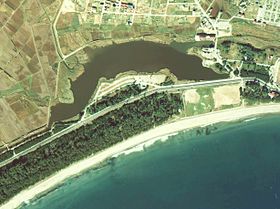 Aerial photo of Old Kawanuma before the 2011 off the Pacific coast of Tohoku Earthquake I make it based on Ministry of Land, Infrastructure and Transport country image information (color aerial photo) (1977 photography) | ||
| The location | Rikuzentakata-shi, Iwate | |
| Position |  | |
| Area | 0.09 [1] km2 | |
| The maximum depth of the water | 5.0 [1] m | |
| The mean depth of the water | 1.77 [2] m | |
| Pondage | 0.000159 [2] km3 | |
| Altitude of the surface of the water | 0 [1] m | |
| The origin | Lagoon | |
| Fresh water, sea mingled with fresh water | Brackish water lake | |
| Wetlands model | Eutrophic lake [2] | |
The lagoon where Old Kawanuma (ふるかわぬま) was in Rikuzentakata-shi, Iwate. It was the greatest natural wetlands in Iwate [1], but most of the sandbar which separated Gulf of Hirota and Old Kawanuma after a massive tsunami caused by the 2011 off the Pacific coast of Tohoku Earthquake generated (2011) on March 11 in 2011 become extinct, and it is under the present conditions in the sea [3].
Table of contents
Summary of Old Kawanuma
It is the lagoon which a part of the Gulf of Hirota is blocked up by a sandbar of approximately 200-300 meters in width that developed near by that Kesen River flows into the Gulf of Hirota in Old Kawanuma, and was formed [4]. Riverbank River of the second grade river which flowed flowed in to run through plains and a city area of Rikuzentakata to the north and south from the northwestern part of Old Kawanuma [5], and small Izumikawa flowed, and two drainages called Takada drainage, the long sand drainage flowed into Old Kawanuma from the eastern part more, too [2]. In addition, Kesen River is left for the record that flowed into Old Kawanuma at the time of a flood before Kesen levee is maintained in form like the present [4].
There was a waterway connected near the Kesen River river mouth from the west of Old Kawanuma, and seawater has ever flowed from the waterway by the flow and ebb of tides. The water gate which limited an inflow of the seawater was established to prevent the damage from salt breeze of the rice field which it was the early modern times, and spread out on the plains of Rikuzentakata-shi, but did not stop inflow itself of the seawater [6]. Old Kawanuma before the 1970s when an inflow of the seawater was seen relatively had good quality of the water, and corbiculae inhabited, and the lake bath was carried out, too [5]. However, Old Kawanuma came to be hit by intense water pollution partly because an inflow of the seawater stopped after having suffered big damage by a seismic sea wave in Chile by an iron gate established in the waterways from Old Kawanuma to the sea being closed, and an inflow of the life drainage continued from the Rikuzentakata city area. Improvement of the quality of the water came to be seen as a result that various efforts were repeated to plan purification of Old Kawanuma that came to have intense pollution, but most of the sandbar which separated Gulf of Hirota and Old Kawanuma by a massive tsunami with the 2011 off the Pacific coast of Tohoku Earthquake that occurred (2011) on March 11 in 2011 became extinct, and, in Old Kawanuma, it has been a part of the sea.
The formation and Old Kawanuma of plains in Rikuzentakata
With the area that is largest in the Sanriku shore which is the Rias coast that a mountain approaches the sea in Rikuzentakata, and continues the complicated topography and the alluvial plain where it is [7]. In the alluvial plain of Rikuzentakata, the formation was started after the last glacial epoch of the glacial epoch by the sea having come to open in Gulf of current Hirota while sea level rose. Sand carried from an upper basin by Kesen rivers still deposited in Hirota inside of the gulf mainly for a while after the last glacial epoch because the Gulf of Hirota was relatively small and was shallow. It was deep, and it was in a big gulf when it became at time of the transgression in Jomon approximately 7,500 years before it became the warm climate before long, and the plains whole area that opened in the current Rikuzentakata-shi center became the sea. Mud deposited in the Gulf of Hirota that became deep mainly these days [4].
When it was approximately 5,400 years ago, the transgression was finished, and the expansion of the Gulf of Hirota was completed, too. Then the delta-related sand of the river came to deposit in the Gulf of Hirota, and 埋積 of the Gulf of Hirota came to advance by Kesen rivers [4]. The alluvial plain of the Rikuzentakata-shi center grew up in a scale of current approximately 4.5 kilometers in width in this way [7]. It is thought that I was formed approximately 1,000 years ago by the sea being partitioned off on the dune which developed in the shore region of the alluvial plain where Old Kawanuma was formed of Kesen River mainly while the alluvial plain of the Rikuzentakata-shi center grows up [8]. In addition, the planting of the pine was pushed forward after the Edo era, and known Takada Matsubara was formed on the dune which developed in the shore part as a beauty spot.
Influence of the seismic sea wave in Chile
The Sanriku coast that was a Rias coast was often hit by a massive tsunami until now. Because Rikuzentakata was hit by (1835), a massive tsunami for Tenpo era six years, and most of pines of Takada Matsubara put on seawater, most withered and died, but there was relatively little damage because Takada Matsubara played a role as trees to protect against tsunami as for Rikuzentakata in itself. In Takada Matsubara, reafforestation was carried out after a tsunami of the Tenpo era, and Takada Matsubara suffered damage of the tsunami by Meiji Sanriku seismic sea wave of (1896), the Showa Sanriku seismic sea wave of 1933 (1933) afterwards in 1896, but there was relatively little damage of Rikuzentakata because Matsubara played a role as trees to protect against tsunami [9].
Rikuzentakata-shi suffered heavy damage by the seismic sea wave that attacked the center at the Sanriku district coast on May 24 in Chile (1960) 1960. At first the tsunami which surged against the Gulf of Hirota sailed up the Kesen River, but the thickness as trees to protect against tsunami let a dike of approximately 3 meters in height built from the thin eastern part in (1908) in 1908 collapse with approximately 1.36 meters low, and, in Takada Matsubara that was on the dune which separated Old Kawanuma and the Gulf of Hirota successively, altitude flowed into Old Kawanuma. And the tsunami which invaded Old Kawanuma flows into the riverbank River more climbing over an embankment in northern marsh, and the low land of the coastal place of Rikuzentakata-shi will be flooded widely [10].
The dike collapsed for approximately 140 meters, and a waterway to tie Old Kawanuma and the sea to for approximately 200 meters mainly on a rip part of the dike has been formed after all. Therefore successful in a temporary dike cutting off sea and Old Kawanuma by the rush work by disaster members of nearly 1,500 dispatched Ground Self-Defense Force on June 16 on June 6 because stay of the salt water continues in Old Kawanuma and, in fact, seawater invades at the time of a high tide by the flow and ebb of tides on the plains of the Rikuzentakata-shi center from part of Shanghai and Old Kawanuma where it has been and adversely affected a civic life [11].
In Takada Matsubara that was on the sandbar which separated Old Kawanuma from the sea, front line bank and a line bank second in 1963 from (1963) in 1 1966 to (1966) and two seawalls were maintained afterwards to (1963) in 1963 from (1960) in 1960 [12]. Front line banks were always established for the purpose of protecting a sandbar with Takada Matsubara exposed to the erosion of the wave in the shoreline and were intended that the second line bank protected farmland or the city area that there was behind Takada Matsubara from a tsunami and were maintained in reference to the tsunami wave height at the time of the Chile seismic sea wave as a seawall of the height of 5.5 meters in the landside of Takada Matsubara [13]. The iron construction gate of the water gate established in the waterways from Old Kawanuma to the river mouth part of the Kesen River in (1968) in 1968 would be closed [† 1], and seawater did not come to flow into Old Kawanuma at the time of a high tide afterwards [5].
The maintenance of the protection against a high tide function and progress of the water pollution

Water of Old Kawanuma flowed out into the sea at the time of ebb tide after the operation of the water gate, and the thing which came and went considerably freely became the sea and the water with Old Kawanuma until now by two seawalls being built after a seismic sea wave in Chile in Takada Matsubara that there was between Gulf of Hirota and Old Kawanuma to prevent tsunami damage, and a water gate being established more at the point equal to the exits from Old Kawanuma to the sea, and an iron gate having been closed, and, in Old Kawanuma, it was a closedown water system cut off from the sea [6].
An inflow of the water from the sea stopped, and Old Kawanuma that became the closedown water system came to be troubled after the 1970s by intense water pollution. As for the reason of the aggravation of the quality of the water, the maintenance of clean water facilities was delayed except that Old Kawanuma was cut off from the sea though becoming it went ahead through the city of Rikuzentakata-shi, and it was big that the life drainage that was not purified for a long time just flowed into Old Kawanuma [14]. The water pollution of Old Kawanuma worsened rapidly, and a red tide was often generated, and sludge came to deposit in the bottom of a lake thick, and, in Old Kawanuma where a corbicula adopted it, and the lake bath was performed once, the pollution that a bad smell drifted was remarkable, and it has been in the marsh which progressed [5].
Effort to purification
"The meeting which cleaned Old Kawanuma" was formed (1982) in December in 1982 by Rikuzentakata citizen in hope of purification of Old Kawanuma that pollution moved. In the meeting which cleaned Old Kawanuma, I held the class of the making of detergent of the use of waste oil which aimed at the Operation of the marsh clean and the spread of no phosphorus detergents, and an action for the purification of Old Kawanuma was started by a citizen [15]. Point of the meeting of organization, Old Kawanuma were the serious pollution statuses that sludge deposited approximately 2 meters on a deep part of the depth of the water of 4-5 meters [16].
Waste water from miscellaneous sources purification facilities business of Old Kawanuma was started in (1984) in 1984, and (1985), Old Kawanuma were appointed in the regulation wetlands of phosphorus in 1985. And a removal experiment of the sludge by the activated sludge method was started in (1987) in 1987 [17].
Old Kawanuma was appointed in the riverbank river water area which was the second grade river of the prefecture management in (1988) in 1988. Riverbank River river purification business was started (1992) from March 1992, and sludge dredging business of Old Kawanuma was started (1993) by Iwate 1993 by a degree and came to be wrestled as a continued project purification of Old Kawanuma for a long term [18]; [5]. Similarly I was chosen in the target point for "clear stream renaissance 21" in 1993 [19], and "clear stream Renaissance 21 riverbank Kawachi area meeting" was formed by Iwate, Rikuzentakata-shi, a citizen group, and the system which wrestled for prefecture, city, the Old Kawanuma purification by the citizen group was hardened [5].
The riverbank river water gate which separated the sea from Old Kawanuma from December was left open (1998) 1998, and seawater came to flow into Old Kawanuma again, and it was pushed forward the sea mingled with fresh water of the lake making it it [20]. And the use of the public sewer was started in April (1999) in a city area of Rikuzentakata-shi in 1999 and was able to continue the dredging business of the sludge of the Old Kawanuma bottom of a lake to a degree (2001) in 2001 [20]. To cleaning activity and life drainage measures around Old Kawanuma by the civic volunteer sink a drainer bag and the activity of "the meeting which cleaned Old Kawanuma" including the distribution were continued and were improved before the quality of the water of Old Kawanuma met the standard of the environmental standard (wetlands B type) [21], and the figure of the waterfowl which came to have little at one time came to be seen again [19]. And the discharge of the Corbicula japonica was tried in 2009, and an effort to regain environment of the Lake ex-Furukawa was continued [22].
Trace of lake bedding of Old Kawanuma and the past tsunami
There is usually Old Kawanuma that is a lagoon separated from the sea by a sandbar to some extent in environment cut off from the sea, but sediment is carried at the time of the tsunami, and it is thought that there is it in the environment that is easy to be saved. Therefore I hung it in the degree (2008) for 20 years, and an investigation about the sediment caused by the past tsunami was carried out (2006) around Old Kawanuma in 2006 by a degree to investigate it what kind of tsunami flocked the past at the Sanriku coast that suffered big damage by many tsunamis in history [8].
As a result, the tsunami sediment thought to be the thing by the seismic sea wave of (1960) in Chile was detected in 1960. And the promising sediment of a tsunami of the Sanriku earthquake of (1933) of the Showa era to a tsunami caused by the Meiji Sanriku earthquake of 1896 (1896) and the tsunami at the time of the Keicho era Sanriku earthquake of Keicho era 16 years (1611) was confirmed in 1933 [† 2]. However, the tsunami sediment caused by the Jogan earthquake of (869 years) was not confirmed for Jogan 11 years. Therefore the generation squeezed the degree in a collected sample (2009) in the old lower part in 2009 and carried out the measurement in the generation of the document, but the tsunami sediment that after all it was thought according to Jogan earthquake was not confirmed. Therefore the possibility that the tsunami of the Jogan earthquake did not reach ashore is pointed out in Rikuzentakata [8].
Extinction caused by the 2011 off the Pacific coast of Tohoku Earthquake

I suffered damage by the seismic sea wave in Chile, and it was Takada Matsubara and Old Kawanuma where the reinforcement of the protection against a high tide function was pushed forward, but Takada Matsubara suffered crushing damage by a tsunami with the 2011 off the Pacific coast of Tohoku Earthquake that occurred (2011) on March 11 in 2011. The tsunami more than 10 meters of wave height destroyed two seawalls, and sandbar in itself, many parts which Takada Matsubara was formed have sunk in the sea. As a result, Old Kawanuma was connected to the sea as far as it was wide and, in fact, has become a part of Shanghai [3].
Footnote
Explanatory note
- The gate of the water gate established in Old Kawanuma and the waterway between the sea in ^ Yoshida, forest hill (1982) having been closed in 1967 of (1967) decide. Here of 1968 (1968) by the description of department of Ofunato, Iwate Regional Development Bureau engineering works engineering works Lesson 2 (2001) it is decided.
- As for the thing (the newest tsunami sediment) of the top, it is thought with the thing by the Chile seismic sea wave in tsunami sediment detected around Old Kawanuma, but, according to Headquarters for Promotion of ^ earthquake research (2009), does it when other tsunami sediment may be sediment of the tsunamis which does not remain for the history record.
Source
- ^ a b c d Yoshida, Wakamatsu, Chiba (1989)
- ^ a b c d Rikuzentakata-shi history editing Committee (1996)p.567
- Action Takuya Tasso (PDF) to the damaged situation and revival in ^ a b Iwate
- ^ a b c d Senda, Matsumoto, Ohara (1984)
- ^ a b c d e f 古川沼をきれいにする取り組み(岩手県川原川)岩手県大船渡地方振興局土木部工務第二課 (PDF)
- ^ a b 吉田、森丘(1980)
- ^ a b 貝塚、成瀬、太田(1985)pp.97-109
- ^ a b c 津波堆積物調査にもとづく地震発生履歴に関する研究 東北地方太平洋沿岸域における地質調査地震調査研究推進本部 (PDF)
- ^ 小田(2003)pp.209-214
- ^ 今野、北村、小高、片岡(1960)、陸前高田市史編纂委員会(1996)pp.557-560
- ^ 陸前高田市史編纂委員会(1996)pp.560-563
- ^ 陸前高田市史編纂委員会(1999)pp.504-506
- ^ 小田(2003)pp.209-210、首藤(2011)「三陸地方の津波の歴史 その4 高田松原」pdfファイル
- ^ 吉田、森丘(1982)
- ^ 陸前高田市史編集委員会(1996)p.568
- ^ 岸(1990)p.180
- ^ 陸前高田市史編集委員会(1996)pp.568-569
- ^ 陸前高田市史編集委員会(1996)p.569
- ^ a b いわてデジタル・エコミュージアム 古川沼及び流入河川の環境保全
- ^ a b 気仙川流域基本計画岩手県 (PDF)
- ^ いわて森・川・海活動事例集 古川沼をきれいにする会
- ^ 東海新報社、2010「昨年放流のシジミ採れず、砂泥地好む貝多く確認、高田小児童が生息調査協力」
参考文献
- 今野円蔵、北村信、小高民夫、片岡純、1960、「チリ地震津波による侵食と堆積について、とくに岩手県三陸海岸高田松原附近を中心として」、『東北地理』第12巻第4号、 東北地理学会
- 吉田稔、森丘直人、1980、「岩手県の湖沼の調査研究 II焼石岳・栗駒山地域および海岸地域の湖沼について」、『岩手大学農学部報告』第15巻第2号、 岩手大学農学部
- 吉田稔、森丘直人、1982、「陸前高田市『古川沼』の水質汚濁問題」、『日本土壌肥料学会講演要旨集』 NAID 110001781378
- 千田昇、松本秀明、小原真一、1984、「陸前高田平野の沖積層と完新世の海水準上昇」、『東北地理』第36巻第4号、 東北地理学会
- 貝塚爽平、成瀬洋、太田陽子、1985、『日本の平野と海岸(日本の自然4)』、岩波書店 ISBN 4-00-007674-4
- 吉田稔、若松善彦、千葉斐子、1989、「岩手県の湖沼の調査研究 III補遺および集成」、『岩手大学農学部報告』第19巻第2号、 岩手大学農学部
- 岸博、1990、『澄んだ湖が帰ってくる』、同友社 ISBN 4-496-01710-5
- 陸前高田市史編集委員会、1996、『陸前高田市史』第七巻 沿革編(下)、 陸前高田市
- 陸前高田市史編集委員会、1999、『陸前高田市史』第八巻 治安・戦役・災害・厚生編、 陸前高田市
- 小田隆則、2003、『海岸林をつくった人々』、北斗出版 ISBN 4-89474-033-8
外部リンク
- 達増拓也、2011、「岩手県における被災状況と復興への取組」pdfファイル
- 岩手県大船渡地方振興局土木部工務第二課、2001、「古川沼をきれいにする取り組み(岩手県川原川)」東北地方整備局河川部地域河川課、pdfファイル
- 岩手県、2007、「気仙川流域基本計画」岩手県、pdfファイル
- 岩手県、2008「いわて森、川、海活動事例集 古川沼をきれいにする会」岩手県
- 地震調査研究推進本部、2009「津波堆積物調査にもとづく地震発生履歴に関する研究 東北地方太平洋沿岸域における地質調査」地震調査研究推進本部、pdfファイル
- いわてデジタル・エコミュージアム 古川沼及び流入河川の環境保全
- 首藤伸夫、2011「三陸地方の津波の歴史 その4 高田松原」pdfファイル
This article is taken from the Japanese Wikipedia Old Kawanuma
This article is distributed by cc-by-sa or GFDL license in accordance with the provisions of Wikipedia.
In addition, Tranpedia is simply not responsible for any show is only by translating the writings of foreign licenses that are compatible with CC-BY-SA license information.
0 개의 댓글:
댓글 쓰기