梶取埼灯台
| 梶取埼灯台 | |
|---|---|
| | |
| Beacon number | 2884 [F6002] |
| Position | 33°34'56" N 135°57'31" E / 33.58222 degrees N 135.95861 degrees E coordinate: 33°34'56" N 135°57'31" E / 33.58222 degrees N 135.95861 degrees E |
| The location | WakayamaHigashimuro-gunTaiji-cho梶取崎 |
| Paint; structure | White, tower form is concrete |
| Lens | 40cm turn light device |
| Quality of light | 1 flashes for 単閃白光毎 eight seconds |
| The effectiveness intensity of light | 250,000 cd |
| Light range | 17.5 nautical miles (approximately 32km) |
| Tower High School | 16m (- tower top above the ground) |
| Light altitude | 41m (mean sea level - light) |
| The first lighting | November, 1899 |
| The jurisdiction | Coast Guard fifth Regional Coast Guard Headquarters |
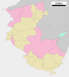
梶取埼灯台 (かんどりざきとうだい) is a lighthouse built in 和歌山県東牟婁郡太地町梶取崎. The outskirts are appointed in the special area of Yoshino-Kumano National Park and become the beauty spot overlooking the Pacific. The place name called 梶取崎 is said to be associated with a ship navigating Nada, Kumano taking Kaji at this cape.
History
"Yamami" to discover a whale was put, and there was the Funami guard station where beacon ground and first generation Kishu feudal lord, Yorinobu Tokugawa who sent an order to a whaler installed it in (1619) at the time for Genna five years in old days for a long time because it was an important point of the traffic on the seas.
There was a candlestick installed in (1636) for Kanei era 13 years in nearby 燈明崎, but it was abolished in (1872) in 1872, and the traffic on the seas of 梶取崎付近 became extremely inconvenient. Therefore I was completed (1899) in November in 1899 and was turned on for the first time.
Neighboring information
Allied item
This article is taken from the Japanese Wikipedia 梶取埼灯台
This article is distributed by cc-by-sa or GFDL license in accordance with the provisions of Wikipedia.
In addition, Tranpedia is simply not responsible for any show is only by translating the writings of foreign licenses that are compatible with CC-BY-SA license information.


0 개의 댓글:
댓글 쓰기