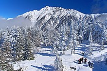
Upper treasure village
| Upper treasure village | |
|---|---|
| Abolition day | February 1, 2005 |
| Abolition reason | Admission merger Nyuukawa-mura, Kiyomi-mura, Shokawamura, Miyamura, Kuguno-cho, Asahi-mura, Takane village, Kokufu-cho, upper treasure village → Takayama-shi |
| The current local government | Takayama-shi |
| Data at the time of the abolition | |
| Country | |
| District | The Chubu District, the Tokai district |
| The metropolis and districts | Gifu |
| County | Yoshiki-gun |
| Group cord | 21,626-7 |
| Area | 475.12km² |
| Total population | 3,780 people (population, January 1, 2005 by estimate) |
| The adjacent local government | Hida-shi、Nyuukawa-mura、Kokufu-cho Nagano Minamiazumi-gunAzumino village、Omachi-shi Toyama Kaminiikawa-gunDaisen-cho |
| Tree of village | White birch |
| Upper treasure village office | |
| The location | 〒506-1392 It is treasure village 540, Hongo in Yoshiki-gun, Gifu |
| Coordinate | 36°17'N 9.9 seconds 137°21'E 48.5 seconds |
 | |
| Wiki project | |
An upper treasure village (chew a treasure irregularity) is the village which was in Yoshiki-gun, Gifu. It was admitted into Takayama-shi with 6 villages except Shirakawa-mura of Ono-gun and 2 municipalities of Yoshiki-gun on February 1, 2005. The house indication after the merger the northwestern part "Takayama-shi Takaramachi ○○", southeastern part "become Takayama-shi Okuhida Onsengo ○○".
Table of contents
Summary
In the mountain village that belonged to Yoshiki-gun, Gifu, and contacted with Nagano, Toyama, I was greatest before the great merger of the Heisei under about 475km2 and Gifu. There is Mts. Hida (the Northern Alps) on the east side of the village, and there is known Awa Pass at a difficult place of the traffic in the southeastern part. The Takahara River started from Mts. Hida cruises in the west and forms a deep gorge.
The villages disperse in the eastern part leading Muranishi part and Okuhida Onsengo with the government office.
- A mountain: Mt. Goro Kurobe、Mt. sugoroku、Momizawadake、Kasagatake、Hotakadake、Yakedake、Norikuradake、Mitsumata-Rengedake
- A river: The Takahara River, Kamata River
History
- A treasure village is formed by the municipality organization enforcement (1889) in Yoshiki-gun on July 1 in 1889
- It is admitted into Takayama-shi (2005) with Nyuukawa-mura, Ono-gun, Kiyomi-mura, Shokawamura, Miyamura, Kuguno-cho, Asahi-mura, Takane village, Kokubucho, Yoshiki-gun on February 1 in 2005
Administrative
- A village mayor: Tsuyoshi Koike (from August 31, 1994 to February 1, 2005)
Education
- Junior high school
- North edge Junior High School
- Elementary school
- Tochio Elementary School
- Hongo Elementary School
Traffic
- Railroad
- There is no pike in a village
- Road
- Central part traversing Expressway(Awa gap wayFlat bath IC)
- National highway No. 158
- National highway No. 471
- Gifu prefectural road 76 Kokufu Miza line
- It is a treasure line in Gifu prefectural road 89 Takayama
- Gifu prefectural road 475 Yarigatake Park line
- Gifu prefectural road 477 Nagakura Kamioka Line
- Gifu prefectural road 485 flat hot water Kute Line
Sightseeing spot

- Okuhida Onsengo
- Oku-hida bear ranch
- Oku-hida toy Museum
- Upper treasure plateau skiing area (closed down with a season in 2000)
- Hirayu Onsen skiing area
- Upper treasure Tokai country club (closed down from about 2009)
Allied item
Outside link
This article is taken from the Japanese Wikipedia Upper treasure village
This article is distributed by cc-by-sa or GFDL license in accordance with the provisions of Wikipedia.
In addition, Tranpedia is simply not responsible for any show is only by translating the writings of foreign licenses that are compatible with CC-BY-SA license information.
0 개의 댓글:
댓글 쓰기