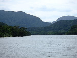
The Urauchi River
| The Urauchi River | |
|---|---|
 | |
| Water system | The second grade water system Urauchi River |
| Classification | The second grade river |
| Extension | 18.8 km |
| Altitude of the water source | 311.7 m |
| Basin area | 54.24 km² |
| Water source | The neighborhood of Mt. Kuwagi |
| River mouth, junction | The East China Sea |
| Basin | Iriomotejima (Okinawa) |
The Urauchi River (うらうちがわ) is the second grade river flowing through the Iriomotejima central part of Yaeyama-gun, Okinawa. It is the longest river in Okinawa, and quantity of water is abundant.
Summary
State of the basin
I assume the neighborhood of Mt. Kuwagi of 312m above sea level in the center of the island the source and drift to the geological feature structure towards northwest direction while having limitation, and most of the basins are included in Iriomote-Ishigaki National Park. The establishment of the Kumamoto Regional Forestry Office was established in the midstream east bank early in the Showa era, and I performed felling or planting of the wood, and a small village was formed, but when the Pacific War began, the business was canceled, and the village was abolished by a flood in 1944, too.
Neighborhood of river mouth
Seawater sails it up from the river mouth at the time of a high tide to a warship rock of approximately 8 kilometers [1]. The neighborhood becomes the tideland of the very large estuary, and mangrove forest consisting of seven kinds of trees including Bruguiera conjugata and the Kandelia Candel develops [1]. There was アトゥク island in the river mouth central part, and the both sides were cormorant radaとよばれる rice field zones.
I forded it by a ship until 浦内橋 was built in 1969. A coal mine was ever it in an anchorage in the river mouth part in the eastern part of the bridge [2]. It can go up by ship now from the anchorage of 浦内橋横 to the 8km upper reaches [1]. When 2km walks, I can go to a waterfall of マリユドゥ and a waterfall of カンピレー. In the mountain path following along the river from the upper reaches anchorage, it is in a course of the tall and stout ecotourism to cross the island halfway along Yoshikawa and Nakama River in front.
Bridge
- 浦内橋 - (Okinawa prefectural road 215)
Allied item
References
- Japanese history place name outline (the online version) Shogakukan (database made from "Japanese history place name outline" Heibonsha Publishers Ltd., 1979 through 2002)
- The ^ a b c Tsuyoshi Nakamura, supervision "see it; is 36 pages in unevenness and burr (why don't take the Japanese Islands, the water?visual topography guidance 2), Tokuma Shoten, 2015 of the land".
- ^ "both islands illustrated map book"
This article is taken from the Japanese Wikipedia The Urauchi River
This article is distributed by cc-by-sa or GFDL license in accordance with the provisions of Wikipedia.
In addition, Tranpedia is simply not responsible for any show is only by translating the writings of foreign licenses that are compatible with CC-BY-SA license information.


0 개의 댓글:
댓글 쓰기