Higoshi-cho
| Higoshi-cho | |
|---|---|
| — 町丁 — | |
 | |
 Higoshi-cho | |
| A coordinate: 36°25'13" N 139°10'25" E / 36.42028 degrees N 139.17361 degrees E | |
| Country | |
| The metropolis and districts | |
| Cities, towns and villages | |
| Area | |
| - 計 | 1.52km2 (0.6mi2) |
| Population (as of the end of August, 2015) [1] | |
| - 計 | 3,226 people |
| - Population density | 2,122.4 /km² (5,496.9 /mi²) |
| Equal time obi | JST (UTC +9) |
| Zip code | 371-0221 |
| Number plate | Maebashi |
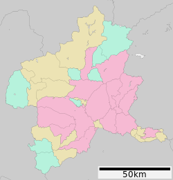
Higoshi-cho (ひごしまち) is the place name of Maebashi-shi, Gunma. It is the place name equal to former ooaza-Higoshi, Ogomachi, Seta-gun [2]. The zip code 371-0221 [3]. The area 1.52km2 (as of 2013) [4].
Table of contents
Geography
There is much population following Motegi-machi in the Daigo district.
History
I pr Maebashi-shi merger
- Cities, towns and villages system is enforced in 1889, and one town 7 village merges, and it is in Gunma south Seta-gun Daigo village larger section of a village Higoshi.
- I belong to Seta-gun by county unification (unification of East Gunma county and south Seta-gun) in 1896 and become Seta-gun Daigo village larger section of a village Higoshi.
- Daigo village enforces town organization in 1899, and Ogomachi is established and becomes ooaza-Higoshi, Ogomachi, Seta-gun.
Maebashi-shi merger post
- Ogomachi merges with Maebashi-shi by a great merger of the Heisei with Miyagimura, Kasukawa-mura in 2004 and becomes Higoshimachi, Maebashi-shi, Gunma
Education
In the elementary school, Maebashi-shi Rikkyo University Azuma Hu Elementary School, the junior high school go to school in Maebashi City Daigo Junior High School [5].
Traffic
Railroad
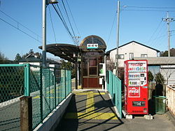
Jomo Denki Tetsudo Jomo LineHigoshi StationBut, there is it.
Bus
With oldness and the bus of the demand-activated bus method that Akagi taxi operates [6].
Road
There is not the national highway, and Gunma prefectural road 3 Oma, Maebashi Kiryu Line, Gunma prefectural road 114 seedling ヶ island Iidoi Line pass the prefectural road.
Facilities
- Jomo Denki Tetsudo Higoshi Station
- Maebashi-shi firefighting station east fire department
- It is a Government building for Azuma Maehashi police station Daigo
Footnote
- ^ "As of Basic Resident Register record population list August 31, 2015". Maebashi-shi. September 17, 2015 reading.
- ^ "list of names of a street after the merger." Maebashi-shi. September 17, 2015 reading.
- ^ "zip code of Higoshi-cho." Mail in Japan. September 17, 2015 reading.
- ^ Chapter 2 population - Maebashi-shi September 17, 2015 reading.
- The ^ "Maebashi City Elementary School and rule about the school district of the junior high school." Maebashi-shi. September 17, 2015 reading.
- The ^ "guidance of oldness and the bus" (demand-activated bus, Daigo, Miyagi, Kasukawa district). Maebashi-shi. May 2, 2015 reading.
This article is taken from the Japanese Wikipedia Higoshi-cho
This article is distributed by cc-by-sa or GFDL license in accordance with the provisions of Wikipedia.
In addition, Tranpedia is simply not responsible for any show is only by translating the writings of foreign licenses that are compatible with CC-BY-SA license information.
0 개의 댓글:
댓글 쓰기