National highway No. 174
| General national highway | |
|---|---|
|
| |
| National highway No. 174 | |
| Total extension | 0.1871 km |
| True extension | 0.1871km |
| The existing way | 0.1871km |
| The establishment year | 1953 designation |
| The starting point | Kobe Port(HyogoKobe-shiChuo-ku) (Map) |
| Terminal | Chuo-ku, Kobe-shi, Hyogo Intersection (map) in front of the customs |
| Is connected Main road (Scale) | |
| ■Template (■ notebook ■ how to use )■ Wiki project road | |

National highway No. 174 (174 ごう which how about to release) is a general national highway reaching National highway No. 2 from the Kobe Port of Chuo-ku, Kobe-shi, Hyogo.
Table of contents
Summary
On so-called port national highway, is a short national highway of the best distance in Japan [1]; [2].
Route data
Origin-destination based on government ordinance [3] [explanatory note 1] appointing the route of the general national highway and the progress grounds are as follows.
- The starting point: Kobe Port (in front of Kobe Customs House central government office.approximately 40m north of the third breakwater intersecting point)
- A terminal: Chuo-ku, Kobe-shi (intersection = National highway No. 2 point of intersection in front of the customs)
- Route extension : 0.1871km [2]
- Designated section : Unavailable [4]
Short-range national highway
Order (as a short distance) of the total extension
- National highway No. 174: 187.1m (the Japan's shortest-range national highway)
- National highway No. 130: 482m
- National highway No. 198: Approximately 600m [5]
Order (as a short distance) of the true extension [6]
- National highway No. 174: 187.1m (the Japan's shortest-range national highway)
- National highway No. 189: 360m
- National highway No. 130: 482m
History
I appear in a Department of the Interior notification sixth "country way list" of (1885) as National highway No. 3 "Tokyo twist Kobe Port ニ through route" in 1885. As for this, National highway No. 4 (from Tokyo Nagasaki) lengthened from Kobe of the terminal by National highway No. 2 (from Tokyo Osakako.existing 1) and the route that repeated to Kyoto. The laws and ordinances top became "the route that reached the Kobe Port from Tokyo", but it was the route that reached Kanbe from Kyoto substantially and was a part of the route that reached Nagasaki. (National highway No. 2 is reference, too)
It was for the route authorization based on the old road law of the enforcement (1920) in National highway No. 38 "Tokyo City twist Kobe Port ニ through route" in 1920. The route name is about the same, but this route repeats with National highway No. 2 "Tokyo City twist 鹿兒島縣廳所在地 ニ through route" (the former) to Kobe and is the route that diverges in Kanbe, and reaches the Kanbe Port, and character of today's National highway No. 174 is near. But the route reaches the Kobe Customs House passing through middle breakwater (fist park) before, and is different from today's route. In addition, Kobe Port was a terminal to be shown in the route name.
It was in the second grade National highway No. 174 Kobe Port line that started from the Kobe Port by route designation based on the new road law on May 18, 1953, and assumed a point of intersection (Ikuta, Kobe-shi ward (existing Chuo-ku)) with National highway No. 2 a terminal.
Current National highway No. 2 curved to the right angle in Azuma Sannomiya intersecting point just before JR Sannomiya Station when I came from the east and went south in the underpass of the Portliner, but went straight to it in those days at the Sannomiya station square. Therefore a road of approximately 940m to link the Sannomiya intersecting point in front of Sannomiya Station directly from the Kobe Port was appointed at National highway No. 174. Because National highway No. 2 was changed to the current course, a point of intersection with National highway No. 2 would move to the Kobe Port side, and, in 1962, only 187.1m on the sea side became National highway No. 174. Remaining more than 750m becomes the Hyogo prefectural road 30 Shinkobe station line of the nickname called "a flower road" now.
On April 1, 1965, distinction of the first class, the second grade disappears by road law revision and appoints it as general National highway No. 174 and takes effect [7].
Because Ikuta, Kobe-shi ward and 葺合区 merged in 1980 and became Chuo-ku, I changed the terminal to "Chuo-ku, Kobe-shi" on April 1, 1982 [8].
Route situation
I it under an alias
- Kobe Port national highway
Geography
Local government to pass
Route to intersect
Image e
-

National highway No. 174 mark (the starting point side). The left is the Kobe Customs House old building.
-
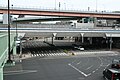
National highway No. 174 "whole view" (some points where, from sidewalk Hashigami in the intersecting point in front of the customs of the terminal, faced the starting point side of the south direction, and the road curved to the starting point.)
Footnote
Explanatory note
- The notation based on the government ordinance (March 19, 2004 government ordinance 50th) on March 19, 2004 that is a last revision day of the government ordinance appointing the route of the ^ public national highway.
Source
- ^ Kenji Asai 2001, p. 49.
- ^ a b "Common question". Ministry of Land, Infrastructure and Transport Kinki district maintenance station Hyogo national highway office. November 8, 2012 reading.
- The ^ "government ordinance (March 29, 1965 government ordinance 58th) which appoints a route of the general national highway." Laws and ordinances data offer system. The Ministry of Internal Affairs and Communications administration Administration Bureau. November 8, 2012 reading.
- The ^ "government ordinance (June 2, 1958 government ordinance 164th) which appoints a designated section of the general national highway." Laws and ordinances data offer system. The Ministry of Internal Affairs and Communications administration Administration Bureau. November 8, 2012 reading.
- ^ "Route distinction of the table 26 public national highway, the road present situation according to the metropolis and districts (PDF)". Road statistics annual report 2012. Ministry of Land, Infrastructure and TransportRoad BureauIt is p. 11. February 19, 2013 reading.
- "The comparison of ^ Kokudo of Japan and the national highway of the beach street." Ministry of Land, Infrastructure and Transport Tohoku district maintenance station Iwaki national highway office. November 8, 2012 reading.
- Government ordinance (March 29, 1965 government ordinance 58th) which appoints the route of the ^ public national highway
- The ^ "government ordinance (April 30, 1981 government ordinance 153rd) which revises a part of the government ordinance appointing a route of the general national highway." The storage of law. October 29, 2014 reading.
References
- On Kenji Asai "dictionary Japan business publishing company that a way is identified as a way", November 10, 2001, it is a first edition. ISBN 4-534-03315-X。
Allied item
Outside link
- Kobe-shi
- Of Kobe rise: Central part construction office manages the whole line
This article is taken from the Japanese Wikipedia National highway No. 174
This article is distributed by cc-by-sa or GFDL license in accordance with the provisions of Wikipedia.
In addition, Tranpedia is simply not responsible for any show is only by translating the writings of foreign licenses that are compatible with CC-BY-SA license information.


