Horsetail lake
| Horsetail lake (south Shiio adjustment reservoir) | ||
|---|---|---|
 | ||
| The left bank location | ooaza-Shiio, Makabemachi, Sakuragawa-shi, Ibaraki grounds | |
| Position |  | |
| River | TonegawaWater systemHaze ヶ 浦 | |
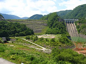
| Dam lake | Horsetail lake (south Shiio adjustment reservoir) | |
| Dam specifications | ||
| Dam model | Zonal model earth-fill dam | |
| Bank High School | 27.4 m | |
| Mayor of bank top | 400m | |
| Bank volume | 563,000 m³ | |
| Basin area | 1.3 km² | |
| Flooding area | 12 ha | |
| Total storing water capacity | 560,000 m³ | |
| Effective storing water capacity | 522,000 m³ | |
| Use purpose | Irrigation | |
| The business main constituent | Aquatic resources mechanism The Ministry of Agriculture, Forestry and Fisheries Kanto agricultural administration station | |
| Construction supplier | MAEDA CORP.・Sanko Kensetsu Kogyo・P.S. Mitsubishi Construction Co., Ltd. | |
| Start of construction age / completion year | 1983 /1991 age | |
| The source | [1] | |
The horsetail lake (arrive spread) a lake [2] in Sakuragawa-shi, Ibaraki. Was completed at a man-made lake (dam lake) built as south Shiio adjustment reservoir (みなみしいおちょうせいち) which made a part of haze ヶ 浦用水事業 in (1992) in [3], 1992 [4]; (1991 [2]). In earth-fill dam [3] (with "a dam manual" rock-fill dam [2]) of 27.4 meters in height, it is aquatic resources mechanism, Ministry of Agriculture, Forestry and Fisheries Kyodo Shisetsu [3]. I save water of haze ヶ 浦 which I drew from haze ヶ 浦揚水機場 [3]. Haze ヶ 浦用水 is used in agriculture (irrigation) water, water for industrial use way water, waterworks water [3].
It is located in the foot of Mount Tsukuba, and "inverse Tsukuba" is reflected in the surface of a lake on the day when the wind is calm [4]. I am known as a famous spot of cherry tree [5].
Table of contents
Traffic access
- Public transport [4]
- It is 30 minutes by taxi from JR Mito Line, Iwase Station.
- Car [4] for private use
- Kita Kanto Expressway・Sakuragawa Chikusei interchangeからCarで 30 minutes. I have a parking lot where I can park of 44.
Footnote
- The ^ dam form, business main constituent "haze ヶ 浦用水 guide" others with "a dam manual" (April 23, 2016 reading).
- ^ a b c "Dam manual south Shiio adjustment reservoir". Association of Nippon Dom. April 23, 2016 reading.
- ^ a b c d e "haze ヶ 浦用水 guide"
- ^ a b c d "Horsetail lake". Sakuragawa-shi tourist association (March 31, 2016). April 23, 2016 reading.
- ^ "visiting cherry trees of Sakuragawa-shi." Sakuragawa-shi tourist association (March 25, 2016). April 23, 2016 reading.
References
- Aquatic resources mechanism haze ヶ 浦用水管理所 "haze ヶ 浦用水 guide"
Allied item
Outside link
This article is taken from the Japanese Wikipedia Horsetail lake
This article is distributed by cc-by-sa or GFDL license in accordance with the provisions of Wikipedia.
In addition, Tranpedia is simply not responsible for any show is only by translating the writings of foreign licenses that are compatible with CC-BY-SA license information.