Hiroshima region meteorological observatory
| Hiroshima region meteorological observatory | |
|---|---|
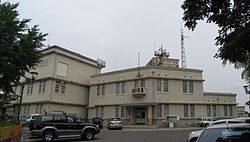
 Hiroshima region meteorological observatory (Hiroshima combination Government building Building No. 4) | |
| Classification | Local Meteorological Observatory Local forecast center government agency |
| Jurisdiction | Hiroshima (Tottori、Shimane、Okayama) |
| The location | 6-30, Kamihacchobori, Naka-ku, Hiroshima-shi, Hiroshima |
| Link | Official site |
The Hiroshima region meteorological observatory (whether Hiro Island Chiho is isolated, and you carry it) is Local Meteorological Observatory in Naka-ku, Hiroshima-shi, Hiroshima. It is the jurisdiction of the Osaka district meteorological observatory and is forecast center government agency unifying the Chugoku districts except Yamaguchi.
Table of contents
Summary
I perform the weather of Hiroshima above the ground, the observation of the biological season, the seismic intensity observation of the earthquake and announce a weather forecast, weather warning, a warning, information, earthquake information, the Earthquake Early Warning, an eruption warning, the eruption forecast in a weather forecast, a week and perform the monitoring of the weather condition of the Chugoku district except Yamaguchi as the district forecast center.
In addition, Shimonoseki Local Meteorological Observatory having jurisdiction over Yamaguchi of the same Chugoku district belongs to the local forecast ward of Fukuoka not Hiroshima, and the district meteorological observatory is Fukuoka not Osaka, too.
History

- The Hiroshima meteorological observatory foundation (1879) - Hiroshima Prefectural for 1,879 years on January 1.
- I was put in Hiroshima Government building of Kakomachi, Hiroshima-shi [1].
- I am renamed to - Hiroshima Prefectural Hiroshima first prize meteorological observatory (1888) on July 1 in 1888.
- A move [1] (1892) new 1892 in December in - 広島市国泰寺村 (existing Chidacho, Naka-ku).
- The concrete place is unidentified.
- I am renamed to - Hiroshima Prefectural Hiroshima meteorological observatory (1919) on May 15 in 1919.
- A move (1935) new 1935 on January 1 in - 広島市江波町 (existing Ebaminami, Naka-ku).
- This hit current 広島市江波山気象館 and was used until 1987.
- It becomes - government management transfer, the Central Meteorological Observatory Hiroshima meteorological observatory (1939) on November 1 in 1939.
- I am renamed to - Hiroshima region meteorological observatory (1943) on November 15 in 1943.
- I am renamed to - Hiroshima district meteorological observatory (1945) on August 11 in 1945. I add a meteorological observatory.
- I abolish - Hiroshima district meteorological observatory meteorological observatory (1949) on June 1 in 1949.
- I am renamed to - Hiroshima region meteorological observatory (1949) on November 1 in 1949.
- I move to Kamihacchobori, Naka-ku of - present location (1987) on December 22 in 1987.
Weather forecast division
South Hiroshima
- Hiroshima, Kure - Hiroshima-shi, Kure-shi, Otake-shi, Hatsukaichi-shi, Etajima-shi, Fuchu-cho, Aki-gun, Kaita-cho, Kumano-cho and Saka-cho
- Fukuyama, tail 3-3 original city, Onomichi-shi, Fukuyama-shi, Fuchu-shi, Sera-cho, Sera-gun and Jinseki-Kogen-cho, Jinseki-gun
- Higashihiroshima, Takehara - Takehara-shi, Higashihiroshima-shi and Osaki-Kamijima-cho, Toyota-gun
North Hiroshima
- Detailed north - Miyoshi-shi and Shobara-shi
- Art north - Akitakata-shi, Akiota-cho, Yamagata-gun and Kita-Hiroshima-cho
Location
- 6-30, Kamihacchobori, Naka-ku, Hiroshima-shi, Hiroshima
Means of transportation
- Hiroshima Electric Railway streetcar stop "Tachimachi" getting off, about 10-minute walk.
Local forecast ward jurisdiction meteorological observatory
Tottori region meteorological observatory
| Tottori region meteorological observatory | |
|---|---|
| Classification | Local Meteorological Observatory |
| Jurisdiction | Tottori |
| The location | 109, Yoshikata, Tottori-shi, Tottori |
| Link | Official site |
The Tottori region meteorological observatory (whether you take it, and Chiho is isolated, and you carry it) is Local Meteorological Observatory in Tottori-shi, Tottori. It is the jurisdiction of the Osaka district meteorological observatory.
History
Weather forecast division
East Tottori
- Tottori - Tottori-shi (except the area of eight districts) and Iwami-cho, Iwami-gun
- Eight - Tottori-shi (Kawaramachi, Mochigase-cho and Saji town), Wakasa-cho, Yazu-gun, Chizu-cho, Yazu-cho
The western part in Tottori
- Kurayoshi - Kurayoshi-shi, Misasa-cho, Tohaku-gun, Yurihama-cho, Kotoura-cho and Hokuei-cho
- Yonago - Yonago-shi, Sakaiminato-shi, Hiezu-son, Saihaku-gun, Daisen-cho, Nanbu-cho and Hoki-cho
- Hino - Nichinan-cho, Hino-gun, Hino-cho and Kofu-cho
Matsue Local Meteorological Observatory
| Matsue Local Meteorological Observatory | |
|---|---|
| Classification | Local Meteorological Observatory |
| Jurisdiction | Shimane |
| The location | 7-1-11, Nishitsuda, Matsue-shi, Shimane |
| Link | Official site |
Matsue Local Meteorological Observatory (whether Matsue Chiho is isolated, and you carry it) is Local Meteorological Observatory in Matsue-shi, Shimane. It is the jurisdiction of the Osaka district meteorological observatory.
History
- I install it (1939) as - Osaka district meteorological observatory Matsue meteorological observatory on November 1 in 1939.
- I change a name of it to - Matsue Local Meteorological Observatory (1957) on September 1 in 1957.
- I move to the new Government building of - existing location (1979) on November 1 in 1979.
Weather forecast division
East Shimane
- Matsue - Matsue-shi and Yasugi-shi
- Izumo - Izumo-shi
- Yunnan - Un-nan-shi, Okuizumi-cho, Nita-gun and Iinan-cho, Iishi-gun
West Shimane
- Ota Ochi - Oda-shi, Honcho, Koorigawa, Ochi, Misato-cho and Onan-cho
- - Hamada-shi in western Hamada and Gotsu-shi
- - Masuda-shi, Tsuwano-cho, Kanoashi-gun in western Masuda and Yoshika-cho
Oki
- Oki - Okinoshima-cho, Oki-gun, Ama-cho, Nishinoshima-cho and Chibu-mura
Okayama region meteorological observatory
| Okayama region meteorological observatory | |
|---|---|
 | |
| Classification | Local Meteorological Observatory |
| Jurisdiction | Okayama |
| The location | 1-36, Kuwadacho, Kita-ku, Okayama-shi, Okayama Okayama region combination Government building |
| Link | Official site |
The Okayama region meteorological observatory (whether Kayama Chiho is isolated, and you carry it) is Local Meteorological Observatory in Kita-ku, Okayama-shi, Okayama. It is the jurisdiction of the Osaka district meteorological observatory.
History
- I establish it (1890) as an Okayama Prefectural meteorological observatory in the old Okayama-jo Castle within the castle of - Uchisange, Okayama-shi on November 15 in 1890.
- I move to - 58, Uchisange, Okayama-shi (1896) on June 1 in 1896.
- It becomes - government management transfer (1938) on October 1 in 1938 and is renamed to Okayama meteorological observatory.
- I move to - Tsushimakuwanokicho, Okayama-shi (1949) on April 16 in 1949.
- I am renamed to - Okayama region meteorological observatory (1957) on September 1 in 1957.
- I move to the present location on - 1-36, Kuwadacho, Okayama-shi Okayama region combination Government building the fifth floor (1982) on October 1 in 1982.
Weather forecast division
South Okayama
- Okayama - Okayama-shi, Setouchi-shi, Tamano-shi and Kibi-Chuo-cho, Kaga-gun
- East detailed - Akaiwa-shi, Bizen-shi and Wake-cho, Wake-gun
- Kurashiki - Kurashiki-shi, Soja-shi and Hayashima-cho, Tsukubo-gun
- Well shade - Ibara-shi, Kasaoka-shi, Asakuchi-shi, Satosho-cho, Asakuchi-gun and Yakage-cho, Oda-gun
- Takahashi - Takahashi-shi
North Okayama
- Niimi - Niimi-shi
- Maniwa - Maniwa-shi and Shinjo-son, Maniwa-gun
- Tsuyama - Tsuyama-shi, Kumenan-cho, Kume-gun, Misaki-cho and Kagamino-cho, Tomata-gun
- Katsuhide - Mimasaka-shi, Nishiawakura-son, Aida-gun, Shoo-cho, Katsuta-gun and Nagi-cho
Footnote
- ^ a b Tadashi Yoshida Jiro "Hiroshima guide" Makoto Tomota truth temple, 1913. August 5, 2014 reading.
Allied item
Outside link
This article is taken from the Japanese Wikipedia Hiroshima region meteorological observatory
This article is distributed by cc-by-sa or GFDL license in accordance with the provisions of Wikipedia.
In addition, Tranpedia is simply not responsible for any show is only by translating the writings of foreign licenses that are compatible with CC-BY-SA license information.


