List of new 100 famous mountains in Japan Number Read
Yamana The metropolis and districts Altitude House of geography map Hyakuyama, others Good point 1 れぶんだけ
Hokkaido
490 House of geography map Google map 45°22'21" N 141°00'57" E / 45.372521 degrees N 141.015806 degrees E / 45.372521, 141.015806 Mt. Rebun Floating island of the flower
2 りしりざん
Hokkaido
1,721 House of geography map Google map 45°10'43" N 141°14'31" E / 45.178529 degrees N 141.242056 degrees E / 45.178529, 141.242056 Mt. Rishiri 3 めあかんだけ
Hokkaido
1,499 House of geography map Google map 43°23'11" N 144°00'31" E / 43.386408 degrees N 144.008556 degrees E / 43.386408, 144.008556 Meakandake 4 たいせつざん
Hokkaido
2,291 House of geography map Google map 43°39'49" N 142°51'15" E / 43.663627 degrees N 142.854083 degrees E / 43.663627, 142.854083 Daisetsuzan 5 もいわやま
Hokkaido
531 House of geography map Google map 43°01'20" N 141°19'19" E / 43.022195 degrees N 141.322 degrees E / 43.022195, 141.322 Moiwayama 6 ようていざん
Hokkaido
1,898 House of geography map Google map 42°49'41" N 140°48'40" E / 42.828178 degrees N 140.811167 degrees E / 42.828178, 140.811167 Mount Yotei 7 えさん
Hokkaido
618 House of geography map Google map 41°48'17" N 141°09'58" E / 41.804706 degrees N 141.166028 degrees E / 41.804706, 141.166028 Hyesan 8 おおづくしやま
Aomori
828 House of geography map Google map 41°17'35" N 141°04'06" E / 41.292962 degrees N 141.068389 degrees E / 41.292962, 141.068389 大尽山 9 It is like that
Aomori
1,585 House of geography map Google map 40°39'32" N 140°52'38" E / 40.658945 degrees N 140.877278 degrees E / 40.658945, 140.877278 Hakkoda Mountains 10 Iwaki
Aomori
1,625 House of geography map Google map 40°39'21" N 140°18'11" E / 40.655844 degrees N 140.303028 degrees E / 40.655844, 140.303028 Mount Iwaki 11 しらかみだけ
Aomori
1,235 House of geography map Google map 40°30'27" N 140°01'06" E / 40.5075 degrees N 140.0183 degrees E / 40.5075, 140.0183 Shiragamidake 12 ななしぐれやま
Iwate
1,060 House of geography map Google map 40°04'16" N 141°06'30" E / 40.071025 degrees N 141.108361 degrees E / 40.071025, 141.108361 7:00 Ameyama 13 Iwate
Iwate
2,038 House of geography map Google map 39°51'09" N 141°00'04" E / 39.852607 degrees N 141.001028 degrees E / 39.852607, 141.001028 Mount Iwate 14 くりこまやま
Iwate
Miyagi
1,627 House of geography map Google map 38°57'39" N 140°47'18" E / 38.960931 degrees N 140.788389 degrees E / 38.960931, 140.788389 Mount Kurikoma 15 ざおうさん
Yamagata
Miyagi
1,841 House of geography map Google map 38°07'40" N 140°26'53" E / 38.127756 degrees N 140.448056 degrees E / 38.127756, 140.448056 Mount Zao 16 The top which I got tired of cook it
Akita
1,637 House of geography map Google map 39°45'40" N 140°47'58" E / 39.761111 degrees N 140.799389 degrees E / 39.761111, 140.799389 Akita-Komagatake 17 たいへいざん
Akita
1,170 House of geography map Google map 39°47'49" N 140°18'38" E / 39.796923 degrees N 140.310694 degrees E / 39.796923, 140.310694 Mt. Taihei 18 I do not let it is a butterfly or be
Akita
Yamagata
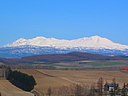
2,236 House of geography map Google map 39°05'57" N 140°02'56" E / 39.099223 degrees N 140.048861 degrees E / 39.099223, 140.048861 Mount Chokai 19 がっさん
Yamagata
1,984 House of geography map Google map 38°32'56" N 140°01'37" E / 38.548912 degrees N 140.026861 degrees E / 38.548912, 140.026861 Tsukiyama 20 Only as for Asahi
Yamagata
1,870 House of geography map Google map 38°15'38" N 139°55'20" E / 38.260515 degrees N 139.922278 degrees E / 38.260515, 139.922278 Mt. Oasahidake 21 にしあづまさん
Yamagata
Fukushima
2,035 House of geography map Google map 37°44'17" N 140°08'26" E / 37.738193 degrees N 140.140667 degrees E / 37.738193, 140.140667 west Mount Azuma 22 りょうぜん
Fukushima
825 House of geography map Google map 37°46'08" N 140°41'14" E / 37.768843 degrees N 140.687139 degrees E / 37.768843, 140.687139 sacred mountain 23 Mt. all today
Fukushima
1,949 House of geography map Google map 37°44'07" N 140°14'40" E / 37.735312 degrees N 140.244361 degrees E / 37.735312, 140.244361 Mt. Issaigyo 24 あだたらやま
Fukushima
1,728 House of geography map Google map 37°37'16" N 140°17'16" E / 37.621142 degrees N 140.287806 degrees E / 37.621142, 140.287806 Mount Adatara 25 ばんだいさん
Fukushima
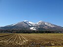
1,819 House of geography map Google map 37°36'03" N 140°04'20" E / 37.600838 degrees N 140.072167 degrees E / 37.600838, 140.072167 Mount Bandai 26 I put it
Ibaraki
654 House of geography map Google map 36°43'27" N 140°25'11" E / 36.724265 degrees N 140.419639 degrees E / 36.724265, 140.419639 Okukuji Mount Nantai 27 Tsukuba
Ibaraki
877 House of geography map Google map 36°13'31" N 140°06'24" E / 36.225314 degrees N 140.106694 degrees E / 36.225314, 140.106694 Mount Tsukuba 28 なんたいさん
Tochigi
2,486 House of geography map Google map 36°45'54" N 139°29'27" E / 36.765129 degrees N 139.490889 degrees E / 36.765129, 139.490889 Mount Nantai 29 たにがわだけ
Gunma
Niigata
1,977 House of geography map Google map 36°50'04" N 138°55'49" E / 36.834492 degrees N 138.930306 degrees E / 36.834492, 138.930306 Tanigawadake 30 Fault ship mountain
Gunma
Nagano
1,423 House of geography map Google map 36°12'14" N 138°38'14" E / 36.203953 degrees N 138.637111 degrees E / 36.203953, 138.637111 Mount Arafune 31 Ryo frow
Saitama
1,723 House of geography map Google map 36°01'24" N 138°50'29" E / 36.023401 degrees N 138.841278 degrees E / 36.023401, 138.841278 Mount Ryokami 32 からすばやま
Chiba
267 House of geography map Google map 35°04'53" N 140°01'31" E / 35.081375 degrees N 140.025333 degrees E / 35.081375, 140.025333 Mt. crow ground 33 Take the spider; a mountain
Tokyo
Saitama
Yamanashi
2,017 House of geography map Google map 35°51'20" N 138°56'38" E / 35.855541 degrees N 138.943889 degrees E / 35.855541, 138.943889 Mount Kumotori The Tokyo highest peak
34 てんじょうさん
Tokyo
572 House of geography map Google map 34°13'10" N 139°09'11" E / 34.219475 degrees N 139.153139 degrees E / 34.219475, 139.153139 Mt. heaven 35 ひるがたけ
Kanagawa
1,673 House of geography map Google map 35°29'11" N 139°08'20" E / 35.486413 degrees N 139.138833 degrees E / 35.486413, 139.138833 Hirugatake 36 Chew; a mountain
Kanagawa
1,438 House of geography map Google map 35°14'00" N 139°01'15" E / 35.233379 degrees N 139.020861 degrees E / 35.233379, 139.020861 Kamiyama 37 どんでんやま
Niigata
940 House of geography map Google map 38°08'37" N 138°23'25" E / 38.143679 degrees N 138.390222 degrees E / 38.143679, 138.390222 Don den mountain 38 ひらがたけ
Niigata
Gunma
2,141 House of geography map Google map 37°00'08" N 139°10'15" E / 37.002111 degrees N 139.170833 degrees E / 37.002111, 139.170833 Hiragatake 39 みょうこうさん
Niigata
2,454 House of geography map Google map 36°53'34" N 138°06'48" E / 36.892711 degrees N 138.11325 degrees E / 36.892711, 138.11325 Mount Myoko 40 あまかざりやま
Niigata
Nagano
1,963 House of geography map Google map 36°54'07" N 137°57'46" E / 36.901978 degrees N 137.962639 degrees E / 36.901978, 137.962639 Mount Amakazari 41 Only as for Asahi
Toyama
Niigata
2,418 House of geography map Google map 36°49'36" N 137°43'48" E / 36.826716 degrees N 137.729889 degrees E / 36.826716, 137.729889 Asahidake 42 Only as for the sword
Toyama
2,999 House of geography map Google map 36°37'24" N 137°37'00" E / 36.62328 degrees N 137.616778 degrees E / 36.62328, 137.616778 Tsurugidake 43 Vertical mountain
Toyama
3,015 House of geography map Google map 36°34'34" N 137°37'11" E / 36.575983 degrees N 137.619722 degrees E / 36.575983, 137.619722 Tateyama 44 Doll
Toyama
Gifu
1,726 House of geography map Google map 36°20'57" N 136°56'23" E / 36.349037 degrees N 136.939722 degrees E / 36.349037, 136.939722 doll mountain 45 I do not win it
Ishikawa
Gifu
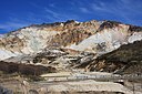
2,702 House of geography map Google map 36°09'18" N 136°46'17" E / 36.155031 degrees N 136.771361 degrees E / 36.155031, 136.771361 Hakusan Heavy snowfall area
46 Only in the fault island
Fukui
1,524 House of geography map Google map 35°56'03" N 136°36'05" E / 35.934189 degrees N 136.601361 degrees E / 35.934189, 136.601361 Arashimadake 47 きんぷさん
Yamanashi
Nagano
2,599 House of geography map Google map 35°52'17" N 138°37'31" E / 35.871441 degrees N 138.625278 degrees E / 35.871441, 138.625278 Mount Kinpo 48 A worth frame surround it
Yamanashi
Nagano
2,967 House of geography map Google map 35°45'28" N 138°14'12" E / 35.757904 degrees N 138.23675 degrees E / 35.757904, 138.23675 Kaikomagatake 49 ほうおうざん
Yamanashi
2,840 House of geography map Google map 35°42'06" N 138°18'17" E / 35.701739 degrees N 138.304667 degrees E / 35.701739, 138.304667 Mount Houou Obelisk
50 のうとりだけ
Shizuoka
Yamanashi
3,026 House of geography map Google map 35°37'16" N 138°14'13" E / 35.621116 degrees N 138.236861 degrees E / 35.621116, 138.236861 Notoridake 51 Mt. combs
Yamanashi
2,052 House of geography map Google map 35°35'12" N 138°22'09" E / 35.5867 degrees N 138.3692 degrees E / 35.5867, 138.3692 Mt. Kushigata Ayame-daira
52 しがさん
Nagano
2,037 House of geography map Google map 36°41'58" N 138°30'40" E / 36.69951 degrees N 138.511167 degrees E / 36.69951, 138.511167 Mt. Shiga 53 Arbor
Nagano
Gunma
2,354 House of geography map Google map 36°32'30" N 138°24'47" E / 36.541778 degrees N 138.412917 degrees E / 36.541778, 138.412917 Mount Azumaya 54 Do; only as for the horse
Nagano
Toyama
2,932 House of geography map Google map 36°45'31" N 137°45'31" E / 36.758601 degrees N 137.758556 degrees E / 36.758601, 137.758556 Shiroumadake 55 からまつだけ
Toyama
Nagano
2,696 House of geography map Google map 36°41'14" N 137°45'17" E / 36.687188 degrees N 137.754694 degrees E / 36.687188, 137.754694 Mt. Karamatsu 56 Grandfather cook it
Toyama
Nagano
2,670 House of geography map Google map 36°35'18" N 137°45'03" E / 36.588315 degrees N 137.750722 degrees E / 36.588315, 137.750722 Mt. Jiigatake 57 つばくろだけ
Nagano
2,763 House of geography map Google map 36°24'25" N 137°42'46" E / 36.406967 degrees N 137.712778 degrees E / 36.406967, 137.712778 Tsubakurodake 58 A spear cook it
Nagano
3,180 House of geography map Google map 36°20'31" N 137°38'51" E / 36.341935 degrees N 137.647528 degrees E / 36.341935, 137.647528 Yarigatake 59 きりがみね
Nagano
1,925 House of geography map Google map 36°06'11" N 138°11'48" E / 36.103145 degrees N 138.196639 degrees E / 36.103145, 138.196639 Kirigamine 60 Only as for the dirt
Nagano
Yamanashi
2,899 House of geography map Google map 35°58'15" N 138°22'12" E / 35.970833 degrees N 138.37 degrees E / 35.970833, 138.37 Akadake The highest peak of the Yatsugatake
61 せんじょうがたけ
Nagano
Yamanashi
3,033 House of geography map Google map 35°43'12" N 138°11'01" E / 35.720009 degrees N 138.183556 degrees E / 35.720009, 138.183556 Mt. 仙丈 ヶ 62 きそこまがたけ
Nagano
2,956 House of geography map Google map 35°47'22" N 137°48'16" E / 35.789431 degrees N 137.804444 degrees E / 35.789431, 137.804444 Kiso-Komagatake 63 おんたけさん
Nagano
3,067 House of geography map Google map 35°53'34" N 137°28'50" E / 35.892838 degrees N 137.480611 degrees E / 35.892838, 137.480611 Mount Ontake Huge independence peak
64 Only as for Hotaka to employ
Gifu
Nagano
3,190 House of geography map Google map 36°17'21" N 137°38'53" E / 36.28918 degrees N 137.648028 degrees E / 36.28918, 137.648028 depths Hotakadake The highest peak of the Northern Alps
65 のりくらだけ
Gifu
Nagano
3,026 House of geography map Google map 36°06'23" N 137°33'13" E / 36.106447 degrees N 137.553583 degrees E / 36.106447, 137.553583 Norikuradake 66 だいにちがたけ
Gifu
1,709 House of geography map Google map 36°00'05" N 136°50'16" E / 36.0014 degrees N 136.8378 degrees E / 36.0014, 136.8378 Dainichigatake 67 あまぎさん
Shizuoka
1,406 House of geography map Google map 34°51'46" N 139°00'06" E / 34.862785 degrees N 139.001639 degrees E / 34.862785, 139.001639 Mount Amagi 68 ぬまづあるぷす
Shizuoka
392 House of geography map Google map 35°03'34" N 138°53'38" E / 35.059403 degrees N 138.893917 degrees E / 35.059403, 138.893917 Numazu Alps 69 wisteria
Shizuoka
Yamanashi
3,776 House of geography map Google map 35°21'38" N 138°43'38" E / 35.360672 degrees N 138.727278 degrees E / 35.360672, 138.727278 Mount Fuji 70 You do it and see it, and hold it
Shizuoka
Nagano
3,047 House of geography map Google map 35°34'26" N 138°10'59" E / 35.5738 degrees N 138.183028 degrees E / 35.5738, 138.183028 Shiomidake 71 You are red, and hold it
Shizuoka
Nagano
3,120 House of geography map Google map 35°27'40" N 138°09'26" E / 35.461209 degrees N 138.157306 degrees E / 35.461209, 138.157306 Akaishidake 72 ほうらいじさん
Aichi
684 House of geography map Google map 34°58'58" N 137°34'59" E / 34.982832 degrees N 137.582944 degrees E / 34.982832, 137.582944 Mount Horaiji 73 おおだいがはらやま
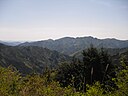
Nara
Mie
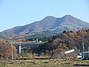
1,695 House of geography map Google map 34°11'07" N 136°06'33" E / 34.185221 degrees N 136.109111 degrees E / 34.185221, 136.109111 Mt. Odaigahara A great quantity of rain zone
74 A beech cook it
Shiga
1,214 House of geography map Google map 35°15'53" N 135°53'49" E / 35.2646 degrees N 135.897 degrees E / 35.2646, 135.897 Mt. Bunagatake 75 あたごやま
Kyoto
924 House of geography map Google map 35°03'36" N 135°38'03" E / 35.060087 degrees N 135.634139 degrees E / 35.060087, 135.634139 Atagoyama 76 いわわきさん
Osaka
897 House of geography map Google map 34°22'27" N 135°33'04" E / 34.374082 degrees N 135.551 degrees E / 34.374082, 135.551 岩湧山 77 ろっこうさん
Hyogo
931 House of geography map Google map 34°46'41" N 135°15'49" E / 34.778014 degrees N 135.263722 degrees E / 34.778014, 135.263722 Mt. Rokko 78 Of the hail do not do it
Hyogo
Tottori
1,510 House of geography map Google map 35°21'14" N 134°30'50" E / 35.353906 degrees N 134.513861 degrees E / 35.353906, 134.513861 Mt. Hyonosen 79 しゃかがだけ
Nara
1,800 House of geography map Google map 34°06'52" N 135°54'11" E / 34.1144 degrees N 135.9031 degrees E / 34.1144, 135.9031 Mt. Shakagatake 80 えぼしやま
Wakayama
909 House of geography map Google map 33°41'46" N 135°54'03" E / 33.696111 degrees N 135.900778 degrees E / 33.696111, 135.900778 Mount Eboshi 81 I do not title it it
Tottori
1,729 House of geography map Google map 35°22'16" N 133°32'24" E / 35.371117 degrees N 133.54 degrees E / 35.371117, 133.54 Daisen 82 さんべさん
Shimane
1,126 House of geography map Google map 35°08'26" N 132°37'18" E / 35.140574 degrees N 132.621556 degrees E / 35.140574, 132.621556 Mount Sanbe 83 ひるぜん
Okayama
Tottori
1,202 House of geography map Google map 35°19'30" N 133°39'49" E / 35.325023 degrees N 133.663583 degrees E / 35.325023, 133.663583 Hiruzen 84 I do not show it
Hiroshima
530 House of geography map Google map 34°16'46" N 132°19'10" E / 34.279568 degrees N 132.319583 degrees E / 34.279568, 132.319583 Mt. Misen 85 ひがしほうべんさん
Yamaguchi
734 House of geography map Google map 34°13'19" N 131°26'34" E / 34.22203 degrees N 131.442861 degrees E / 34.22203, 131.442861 東鳳翩山 86 Sword
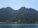
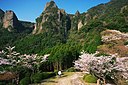
Tokushima
1,955 House of geography map Google map 33°51'13" N 134°05'39" E / 33.853578 degrees N 134.09425 degrees E / 33.853578, 134.09425 pinholder Calm figure of a mountain of Sasabaru
87 That's all right, it is a mountain
Kagawa
422 House of geography map Google map 34°16'28" N 133°50'45" E / 34.274334 degrees N 133.845861 degrees E / 34.274334, 133.845861 Mount Ino Sanuki Fuji
88 Mt. Ishizuchi
Ehime
1,982 House of geography map Google map 33°46'04" N 133°06'54" E / 33.767801 degrees N 133.115056 degrees E / 33.767801, 133.115056 Ishizuchiyama 89 いなむらやま
Kochi
1,506 House of geography map Google map 33°44'49" N 133°21'33" E / 33.747014 degrees N 133.35925 degrees E / 33.747014, 133.35925 rick mountain 90 ひこさん
Fukuoka
Oita
1,200 House of geography map Google map 33°28'35" N 130°55'33" E / 33.476253 degrees N 130.925889 degrees E / 33.476253, 130.925889 Hikosan 91 くろかみやま
Saga
516 House of geography map Google map 33°12'51" N 129°54'06" E / 33.214129 degrees N 129.901778 degrees E / 33.214129, 129.901778 raven-black hair mountain 92 Only as for Fugen
Nagasaki
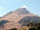
1,359 House of geography map Google map 32°45'36" N 130°17'32" E / 32.759949 degrees N 130.292111 degrees E / 32.759949, 130.292111 Mt. Fugen 93 あそさん
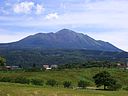
Kumamoto
1,592 House of geography map Google map 32°53'04" N 131°06'14" E / 32.884337 degrees N 131.103861 degrees E / 32.884337, 131.103861 Mount Aso 94 Only as for Yufu
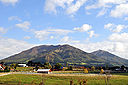
Oita
1,583 House of geography map Google map 33°16'56" N 131°23'25" E / 33.2822 degrees N 131.3903 degrees E / 33.2822, 131.3903 Yufudake 95 くじゅうさん
Oita
1,787 House of geography map Google map 33°04'56" N 131°14'27" E / 33.082146 degrees N 131.240889 degrees E / 33.082146, 131.240889 Mt. Kuzumi 96 そぼさん
Miyazaki
Oita
1,756 House of geography map Google map 32°49'41" N 131°20'49" E / 32.828058 degrees N 131.347056 degrees E / 32.828058, 131.347056 Mount Sobo 97 たかちほのみね
Miyazaki
1,574 House of geography map Google map 31°53'11" N 130°55'08" E / 31.886261 degrees N 130.918944 degrees E / 31.886261, 130.918944 Takachiho peak 98 Only as for the worth thing
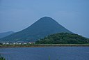
Kagoshima
924 House of geography map Google map 31°10'48" N 130°31'42" E / 31.180071 degrees N 130.528389 degrees E / 31.180071, 130.528389 Kaimondake Beautiful cone
99 ながただけ
Kagoshima
1,886 House of geography map Google map 30°20'34" N 130°29'32" E / 30.342915 degrees N 130.492361 degrees E / 30.342915, 130.492361 Mt. Nagata 100 Only as for the cause
Okinawa
526 House of geography map Google map 24°25'38" N 124°11'00" E / 24.427229 degrees N 124.183417 degrees E / 24.427229, 124.183417 於茂登岳