Storage of one dam
| Storage of one dam | |
|---|---|
 | |
| The left bank location | Hitokura, Kawanishi-shi, Hyogo character Daisen |
| Position |  |
| River | YodogawaWater systemStorage of one main thoroughfare next river |
| Dam lake | Lake Tomoaki [100 selections of dam lakes] |
| Dam specifications | |
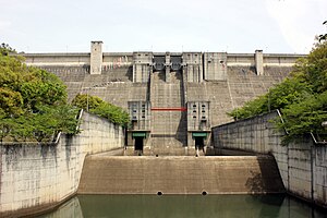
| Dam model | Gravity-type concrete dam |
| Bank High School | 75.0 m |
| Mayor of bank top | 285.0 m |
| Bank volume | 441,000 m³ |
| Basin area | 115.1 km² |
| Flooding area | 140.0 ha |
| Total storing water capacity | 33,300,000 m³ |
| Effective storing water capacity | 30,800,000 m³ |
| Use purpose | Flood control・Indefinite irrigation・Waterworks |
| The business main constituent | Incorporated administrative agency aquatic resources mechanism |
| Construction supplier | OBAYASHI CORPORATION, SATO KOGYO |
| Start of construction age / completion year | 1968 /1983 age |
| The source | Storage of "dam manual" one dam |
| Remarks | Water source area measures special measures law designation Inagawa Valley Prefectural nature park |
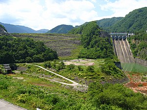
Storage of one dam (ひとくら dam) is a dam built by Kawanishi-shi, Hyogo, the storage of first-grade river, Yodogawa water system one main thoroughfare next (ひとくらおおろじ) river.
A gravity-type concrete dam of 75 meters in height that an incorporated administrative agency aquatic resources system manages. It is a multipurpose dam for the purpose of the waterworks supply to each Inagawa coast local government including Amagasaki-shi including river improvement, Kawanishi-shi of Inagawa, the Kanzakigawa coast of storage of one main thoroughfare next river and the junction. It is the oasis of the Kawanishi citizen who the man-made lake formed of a dam is named Lake Tomoaki (ちみょうこ), and receives recommendation of Kawanishi-shi that is the location local government, and was chosen in 100 selections of Lake dam from dam water source environment maintenance center Foundation.
Table of contents
History
Inagawa had Amagasaki-shi, Toyonaka-shi, Kawanishi-shi, Ikeda-shi, Itami-shi in the basin and was an important point area of the river improvement than old times by also flowing through the central part of the Hanshin industrial area. The "river water control plan" proposal by Nagaho Mononobe becomes the place that the Department of the Interior accepts in (1938) in 1938, and river water control business is developed in 7 river 1 wetlands of the whole country. The importance of the river improvement had been a pending issue after I served, and "Inagawa river water control business" stood up in (1941) in 1941, and "Inagawa Dam plan" happened to Ina River Motokawa as root and trunk facilities by having suffered serious damage caused by the Kobe flood in Inagawa in the same year. However, the business was forced to cancellation with intensification of the Pacific War, and the dam plan came to nothing after the war after all.
Typhoon 13 that brought Yodogawa water system unprecedented damage (1953) in 1953 invited a record flood in Inagawa and caused great damage to the above basin city. Besides, the housing land development around Kawanishi-shi was pushed forward rapidly by being the convincing bedroom town of the Kansai area, and, as a result, the moisture holding ability drop of the basin by the vegetation manipulation became the concern in the river improvement, and immediate river maintenance was demanded. On the other hand, the expansion of the Hanshin industrial area caused increase of the population and the concentration of the factory, and, as a result, the water demand intensified the degree of the stringency rapidly. The Inagawa basin became the pending issue that the new development of aquatic resources was new in addition to conventional river improvement from such a thing, and the time of the river overall development increased.
There was such a point of view, and "Yodo River water system repair basic plan" was already gathered up as a river improvement plan (1954) in 1954, and measure maintenance to control river improvement, irrigation generally was fixed by Yodo River water system having been appointed to the development designation water system of "the aquatic resources development promotion method" successively in (1962) in 1962, and, as for the Yodo River water system, large-scale river overall development came to be dealt with. For the purpose of the flood control in the Inagawa basin and the supply of the waterworks to the Kansai area, it is storage of one dam in this that Water Resources Development Public Corporation (existing incorporated administrative agency aquatic resources mechanism) planned in (1968) in 1968.
Role of the dam
The storage of one dam was added to official business of Water Resources Development Public Corporation in revision of "the Yodogawa water system aquatic resources development basic plan" of 1968. As for Inagawa Motokawa, it was planned residential land in the down stream, the Hitokura, Kawanishi-shi frontage of the storage of one main thoroughfare next river that was 左支川 by progress of becoming it being full of the dam construction remarkably, and difficulty having been expected. A concrete dam, the height gravity-style as for the model of the dam are 75.0m. I have a reservoir of total storing water capacity 33,300,000t. It is a multipurpose dam for the purpose of the waterworks supply to flood control of Inagawa, Kanzakigawa, indefinite irrigation to plan water supply for the existing profit in the military Yukuhashi point, Kawanishi-shi, Ikeda-shi, Toyonaka-shi, Itami-shi, Amagasaki-shi, Nishimiyaichi, Takarazuka-shi, Inagawacho and Toyonocho.
I might say a residential area on the occasion of dam construction and land prices remarkable rise was remarkable and the compensation negotiations ran into difficulties, but it was given (1974) into the first designation dam of the water source area measures special measures law on July 20 in 1974 and exhibited utmost measures about compensation. As a result, the compensation standard settled (1975) in August in 1975, the following day, too. Dam body construction was started, but it was necessary to take special measures for environment measures such as the noise and the water pollution by being the dam construction that was next to the residential area not mountains and was construction specific in this sense afterwards. The dam is completed than plan announcement (1983) in 1983 15 years later and contributes to river improvement, the irrigation of the basin afterward, but there is the bad smell problem of the storage of main thoroughfare next river for one for period at 1:00, and it becomes clear to have, and "flash discharge" to clean mud or the algae of the river to cancel this is carried out by breeding of the algae by the decrease of the running water and does not have the bad smell problem afterward.
Lake Tomoaki

The lake made by a dam is called "Lake Tomoaki (ちみょうこ)" (locally ちめいことも), but this comes from it from the Tomoaki mountain in the neighborhood. By the way, it was said that "a strange mountain" was corrupted into the Mt. Tomoaki and was called it, and there was the mine which produced silver, copper before. In "dam lake 100 selections which the foundation, dam water source environment maintenance center chooses in (2005) in 2005," I am chosen by recommendation of Kawanishi-shi.
A dam and the neighborhood of Lake Tomoaki are appointed in the Inagawa Valley Prefectural nature park and become the hiking course of the Kinki nature walk. In addition, the outdoor spots such as Lake storage of one Park, Kunisaki murmuring open space, Tomoaki campgrounds Hyogo Prefectural in the outskirts are maintained. National highway No. 173 (Nose Highway) may go along the west of the lake, and the access of the traffic is good, too.
- Fishing ground
A new subdivision is near, and there is the history for a long time as a good spot of the large-mouth bass spatula fishing ground from the place where the convenience to transportation is good for. In addition, it is famous even to be able to catch 良型 of the orchid Kirk RAS well. Because the good place of footing lies scattered when I make bank fishing, I can enjoy it from a beginner. I repeat practice at this place, and the famous bus pro learns pattern fishing, too. I can enjoy the mountain stream fishing with the back water (inflow part of the river flowing into the dam lake).
- Leisure
"Storage of river Hajime Nishi dam tour marathon meeting" is carried out in the lakefront on November 23, and the participant more than 2,000 competes for a good walker every year. There are many tourists by the autumn maple-tree viewing.
- Worship
In addition, there is Mt. Myouken near by, and there are many "Myouken of Nose" and people who call it, and go and worship as hallowed ground of the Nichiren sect along with Mount Minobu.
- House
On the other hand, it is an urban dam, and many new residential areas crowd including the Nissei new subdivisions of Maruyamadai, Miyamadai along the Lake Tomoaki. Nose Electric Railway passes a basin, and there is much population as a bedroom town to Osaka-shi, Kobe-shi, too. It is the dam where everyday life coexists with nature.
Later Kanzakigawa, Inagawa river development
Storage of one dam is a finished dam with Kanzakigawa, Inagawa line first. A plan is pushed forward taking advantage of 北摂豪雨 Aigawa dam (中央土質遮水壁型 rock-fill dam .82.5m) as a supporting multipurpose dam Osaka in Aigawa in the Inagawa basin from (1976) in 1976, and Mino River dam (中央土質遮水壁型 rock-fill dam .47.0m) which is a dam for exclusive use of the river improvement in the Mino River which is famous for a waterfall of Minoh is completed for storage of one dam and the same period. In addition, the plan of the Yono River dam (gravity-style concrete dam .74.0m) where the Ministry of Construction (the existing Ministry of Land, Infrastructure and Transport Kinki district maintenance station) was a specific multipurpose dam in the Yono River than 1979 (1979) was pushed forward.
But both Aigawa, Yono River dams of the review of the public works project of the 1990s was baptized, and business froze up virtually. In the Aigawa dam, construction was continued by reducing some scales, but, in the Yono River dam, Ministry of Land, Infrastructure and Transport made a decision of the business cancellation by a report of "Yodogawa water system basin Committee" in 2005. However, the basin local government and move inhabitants repel business cancellation, and the situation shows a changeable aspect, and the river development of the Inagawa basin is in a-like situation in such a transition period.
Access
- Car
- Than Hanshin Expressway Ikeda Line Kibe lamp is approximately 20 minutes at National highway No. 173.
- Train, bus
- From Nose Electric Railway Yamashita Station is approximately ten minutes in Hankyu Bus. Storage of one dam stop getting off, a 7-minute walk.
Allied item
Outside link
- Storage of dam manual (association of Nippon Dom Foundation) one dam
- Incorporated administrative agency aquatic resources mechanism
- Storage of incorporated administrative agency aquatic resources mechanism one dam management place
- Storage of one dam story
- The scenery that set in the storage of one dam
This article is taken from the Japanese Wikipedia Storage of one dam
This article is distributed by cc-by-sa or GFDL license in accordance with the provisions of Wikipedia.
In addition, Tranpedia is simply not responsible for any show is only by translating the writings of foreign licenses that are compatible with CC-BY-SA license information.