It is the name of a prefecture, the local government at the same time as Yasothon is the name of the county. Look at テーサバーンムアン Yasothon about the local government, the city area in Yasothon about the prefecture.
A county (アムプー) in Yasothon in northeastern Thailand in the ムアンヤソートーン county. It is prefectural seat of the prefecture (ムアン).
When plastic war bamboo pipe-stem on Sir (plastic war) which was a minister of Vientiane left with many people for a Cham gone case in 1795, according to "Yasothon chronicle," I settled down here by saying that I found this place where the ghost lived in and was suitable for the residence. This is a beginning of history of Yasothon. This new place of residence was called barn sinter afterwards.
In 1814, the barn sinter was named Yasothon by the Rama second and was considered to be a government controlled area of Bangkok, and plastic スントーンラーチャウォンサー was put as a king.
In 1900, Yasothon was incorporated into Ubon Ratchathani, and Yasothon was divided in the cormorant Thai Yasothon county and パチムヤソートーン county, too. The domain of Yasothon was lowered in 1907.
In 1910, the cormorant Thai Yasothon county moved a county agency to タムボン ルムプック and changed the name to カムクアンケーオ county in 1913, and the パチムヤソートーン county changed Yasothon county and the name into the same year, too [1].
When an area around Yasothon became independent as a prefecture in 1972, the Yasothon county became the prefectural seat.
Geography
It is in the level ground that the tea river formed, and the main water source of the county is a tea river, too.
National highway No. 23 goes for southeast from the northwest and contacts with the Ubon Ratchathani area to Roi Et, the southeast to the northwest. National highway No. 202 runs the east and west and is connected to the スワンナプーム area to Amnat Charoen, the west to the east. In addition, Route 2169 extends to the north and is connected to the ルーンノックター area.
Economic
The main industry is agriculture, and rice, tapioca, a watermelon are cultivated.
I it for an administrative section
The city is divided into 18 タムボン, and the low rank includes 190 villages (Mu barn) more. There is the local government (テーサバーン) and is as follows.
In addition, Tranpedia is simply not responsible for any show is only by translating the writings of foreign licenses that are compatible with CC-BY-SA license information.
In addition, Tranpedia is simply not responsible for any show is only by translating the writings of foreign licenses that are compatible with CC-BY-SA license information.
After graduation from university, I work as a chief engineer in the kolkhoz of the State of Chimkent (State of existing south Kazakhstan) チュリクバス district. Two years later, I am elected by Komsomol チュリクバス district committee's first secretary.
I move to the duties of the party from 1979 and successively hold chief at party district committee section, the second clerk, the first secretary, Kazakh Communist Party executive committee supervisor, State of party committee clerk. In July, 1986, I recommend it to Chairperson of State of Chimkent executive committee. It is Vice-President Kazakh S.S.R. Cabinet meeting first from November, 1989 to February, 1990. A vice-president first from February, 1990 to April of the year. It is the Vice President of Republic of Kazakhstan from April, 1990 to May of the year. It is State of party Chimkent Committee's first secretary and the state people's deputy meeting chairperson from May, 1990 to October, 1991.
It is Prime Minister of Republic of Kazakhstan from October, 1991 to October, 1994. It is the international foundation "インテグラーツィヤ" president from October, 1994.
For 1998 through 1999, I command election campaign headquarter of Nazarbayev. Acting republicanism political party "オタン" party leader counting more than 300,000 party members from March, 1999 to October, 2002.
LitoralレソザヴォーツクI am from a city. I have being married, two girls, granddaughter one.
I graduate from Kazakh agricultural college (1973), Alma-Ata high party school. An economic scientific associate doctor. An international computerization academist.
The hobby reads. The favorite car is Toyota Land Cruiser.
Public office
Predecessors in the family line: (oneself) Prime Minister of Kazakh socialism republic
In addition, Tranpedia is simply not responsible for any show is only by translating the writings of foreign licenses that are compatible with CC-BY-SA license information.
The U.S. forces which had finished almost gaining control of Guam in a fight of Guam in August, 1944 drew up the strategic plan with the Taiwan landing in Philippine Leyte (fight of のちの Leyte) on Luzon (fight of のちの Luzon) or March 1 on landing, February 20, 1945, the following day on December 20, the same year as the next attack plan for the Japanese soil capture, but were not decided at this point in time whether it was Taiwan, or it was Okinawa. However, I judged it from the viewpoint of influence use to Japanese soil with the capture in Taiwan having already reached the limit of the ability for supply from suggestion of Raymond Spruance in September, 1944 in the U.S. NavyUnited States Pacific Fleetheadquarters if there was not a meaning.
Because the Japanese Navy suffered waterloo, in Leyte offing sea fight, the ability for battle disappeared, and strategic value of the capture in Taiwan fell down, but the navy and the army were opposed flatly in the Joint Chiefs of Staff because Douglas MacArthur of the U.S. Army still insisted on the Taiwan capture. Because strategic bombing to Japanese soil where inside, Henry Arnold of the army Airlines forces were more effective was enabled, sang significance of the Iwo-To capture, and a basic strategy called the Iwo-To capture became the policy of the whole U.S. forces as a premise to the Okinawa landing (のちの Okinawa war) 40 days later on October 2 [2].
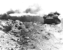
As a result, it was started the cause of supporting it a carrier-based plane and the bombardment of the war vessel Iwo-To fierce attack of the American Marine Corps on February 19, 1945. The U.S. forces approximately bring the islands under control after intense resistance of the Japanese army which assumes Tadamichi Kuribayashigenl. a commander in chief on March 17 approximately one month after the landing, and, on March 21, the Japanese Imperial Headquartersannounces that Iwo-To garrison died an honorable death on 17th. However, the sporadic guerrilla warfare from a residual Japanese soldier continued afterwards, and, on March 26, more than 300 lower than Tadamichi Kuribayashi general carried out the last all-out attack, and the destruction, the in this way Japan-U.S. organized battle terminated.
The Japanese military less has the concrete plan of reinforcement and the relief at first, and 20,129 of 96% are killed in action in 20,933 defense military power or is fighting; was missing. On the other hand, the U.S. forces suffered damage for 28,686 people of 6,821 death in battle, 21,865 war wounds in total. It is the rare fight that damage (the totals of [3] such as the number of the people with death in battle, war wound) real number of the U.S. forces capture corps by the land combat exceeded the Japanese military on the Greater East Asia War (the Pacific War) latter period and I exceed war casualties in the Normandy landing operation (Operation overlord), also known as "the landing operation greatest in history" in the game with Germany (the Western Front) and am known for only three days as one of the most sites of a hard-fought battle of the World War II bending fingers with Philippine fight (1944-1945 years) and Okinawa round after the Iwo-To landing again.
Background
Position relations of Iwo-To and Japanese soil.
Iwo-To is located to south approximately 1,080km of Tokyo, north approximately 1,130km of Guam and is a volcanic island belonging to Ogasawara Islands sulfur Shimamura. This island name was acquired from the place where surface most were covered with a hoarding of sulfur of the island. The longer axis is less than 8km in the southwestern direction from the northeast, and the width is only 800m in approximately 4km, the southern part in the northern part. As for the area, 21km² degree, the highest score are Mount Suribachi of 169m above sea level in the southern part of the island. There was not the water retentivity, and the soil couldn't but depend on salty well water or rainwater for the drinking water for volcanic ashes. Approximately 1,000 inhabitants who ran digging or sugarcane cultivation of sulfur lived before the war.
The Japanese military deployed approximately 1,200 navy base corpses, army military power 3700-3800 in Chichijima at the time of the Greater East Asia War (the Pacific War) outbreak of war of December, 1941 and placed Iwo-To under the jurisdiction of this military unit. After the outbreak of war, importance of Iwo-To was recognized as a way station of the aviation course that linked Japanese soil to the south area (Southeast Asia), and I built the plover airport, and the navy deployed 1,500 air force and 20 planes at the position of northeast approximately 2km of Mount Suribachi.
In February, 1944, the U.S. forces performed a large-scale air raid to the truck Island which occupied Marshall Islands (fight of Gilbert Marshall Islands) and crushed military power of the Japanese Navy including a large number of war vessels and planes (truck island air raid). The Japanese Imperial Headquarters decides to certainly defend a line linking Mariana Islands, Ogasawara Islands from Caroline Islands to the death as the national defense zone. The 31st military which the Lieutenant General of Hideyoshi Obata army commanded as defense military power of the defense line was organized and the Tadamichi Kuribayashi army lieutenant general who remained in the inland as the absence Imperial Guardsman second divisional commander as the 23rd forceschief of staff by south strategy, Hong Kong capture round of the Pacific War beginning of the game in service in a war, capture postwar period was appointed and took office as the Commander Ogasawara district group of subordinates. A reinforcement corps arrived at Iwo-To in April from March, and the total military power reached than 5,000 people.
In the summer of 1944, the U.S. forces captured Mariana Islands (fight of Mariana Islands Palau Islands) and, after November, started long-distance bombing from Mainland China to Japanese soil with the B-29 bomber which went conventionally from the ground (Japanese soil air raid). However, Ogasawara Islands watched the B-29 toward Japanese soil and functioned as a monitoring base of the early-warning system (air defense lookout post) to report by wireless telegraphy. The report from Iwo-To in particular was the most important source of information. The Japanese military was able to in this way let a fighter go to the B-29 interception over the mainland. In addition, without being injured more over Japan, and breaking down, and B-29 being able to arrive by a navigation mistake to Mariana Islands without an escort fighter being able to accompany it because aircraft kilometer performed is one-way approximately 2,000km and long distance by the sortie from Mariana Islands of the B-29; on the sea a crash often made an emergency landing. And bomber, four sets of heavy bomber "enlightened emperors" and the Milky Way of the Japanese military, complete set land air raider often raided an airport in Mariana Islands via Iwo-To and caused damage to B-29 parking on ground. 11 B-29 was destroyed in both chair lei field athlete airports of Saipan by the machine-gun mopping-up of the first Emperor's shield special attack unit which flew away from Iwo-To in December, and eight suffered big damage among other things.
Security of the middle landing field of the bomber which cannot return by the damage, the trouble by the hit, lack of fuel to Mariana Islands
Security of the base of the fighter guarding a bomber
Destruction of the attack base of the Japanese military plane
Destruction of the early warning system of the Japanese military
Cancellation of the loss in the navigation of the bomber by avoiding Iwo-To
As equal を purpose, I decided occupation of Iwo-To [4]. When a fight of Leyte in the Philippines was coming to an end, the Iwo-To capture was decided as a strategic plan to perform for two months until Okinawa invasion, and the a series of attacks operation was named "デタッチメント strategy".
In May, 1944, the Lieutenant General of Tadamichi Kuribayashi army started for its new post as Ogasawara area commander in chief to Chichijima. I was to put the headquarters in Chichijima with the fortress at first, but as a result of having investigated the situation, judged that the U.S. forces attacked Iwo-To with the airport right lot. Italy detached force and a navy corps of the army were located in Iwo-To (in the marshalcy), but matched it with other living-in-Ogasawara area military units and reorganized it in the 109th division (兵団文字符: "膽") on 22nd, and D.H.Q. and the main force moved to Iwo-To, too (they place the combined first regiment in combined second brigade, first brigade combined in Chichijima, Hahajima in Iwo-To).
It was obvious that Iwo-To could not hold out for a long time, but the Ritsurin lieutenant general let the landing party pay value as big as possible and, for U.S. forces with the command of the air and command of the sea, made up my mind to delay an attack to Japanese soil in a day. The evacuation of all the private citizens except an officer, the civilian employee was completed as the first step of the defense plan by late July. Then, the full-scale fortification of the island was drawn up. Because the facilities above the ground are not able to bear bombardment from a warship and bombing, a natural cave and the widespread basement gallery consisting of the artificial galleries will be built.
The construction of the position under the ground and naval opposite
The Japanese army guard of the middle river sandbank man chicken colonel utilized a position under the ground and, in a fight of ペリリュー, succeeded in long-term resistance, but the Ritsurin lieutenant general developed this tactics more. The position construction for general banzai charges performed by fights offight, Saipan of fight, Makin of Tarawa before Lieutenant General Ritsurin Iwo-To arrival at post of June 8, 1944 was pushed forward, but the lieutenant general let you withdraw it as the waste that was meaningless and valuable material and waste of time on the same month 20 and did protracted war and guerrilla warfare (guerrilla) that I invited it in the inland with a basic policy (retreat deployment), and the Italy detached force of the army switched it to rear position construction on 23rd. However, I have extremely strong criticism from the navy side persisting in the plover airport security of the island for this (island garrison and Imperial Headquarters navy part) (construction of the water's edge position and tochka group to the airport neighborhood advice) and will promise some water's edge, airport position construction in the form that the army side (Lieutenant General Ritsurin) concedes it (I convert half of of the navy offer material for the water's edge, the airport position into the rear, basement position construction without the army building it with navy offer material, and cooperating, and Ritsurin lieutenant general changing protracted war (rear, basement position construction) policy at all). In addition, these water's edge, airport positions that the navy required were destroyed with the navy machine, airport function of only ten several hurriedly, but on the other hand they endure the basement position of the army and outrun you, and they are utilized by gun bombing of U.S. forces.
I trained 70% at time for a plan (a mining expert was dispatched for a design by the mainland), a strength of an army, and the Lieutenant General Ritsurin ordered gallery construction of 28km in total length to link the facilities of a backward position and all of the islands in a basement to allot 30% for construction. Because the volcanic rock of Iwo-To was very soft, I was able to dig it with the hand tools such as a cross hoe or the small shovel. In addition, they gave it an order to start position construction for all officers including so-called clerkdom of headquarters, 本部附, and they stopped all salutes during work even at the time of a senior officer round of inspection to get rid of a delay of the construction, and the instructions were thorough reasonably. In addition, I made a circuit around commander in chief (Lieutenant General Ritsurin) oneself Shimauchi each place, and met all 21,000 officers, and I let you enshrine the regimental colors (the colors which assumes the sun flag a design) of the foot soldier 145th regiment in the construction workshop again not the corps headquarters and the regiment headquarters and did it, and rigid impartiality of motivation maintenance and the military discipline of officers pushed on to making it it. However, construction by the manual labor under the ground was a series of difficulty mainly and was able to continue the consecutive work only for five minutes because it was exposed to terrestrial heat from sulfur gas and 30 degrees Celsius that added it to intense manual labor, and couldn't but wear a gas mask to 50 degrees Celsius. Officers were salty, and an acquisition method of the spring water couldn't but depend on the well water which the sulfur smell made for rainwater degree, and I was troubled by intense diarrhea. In addition, the supplement and the treatment were difficult even if casualties by an air raid and the bombardment from a warship of U.S. forces appeared. Work was continued for a password in "I protect one drop of blood on 一掘 りの Saturday", but an illness dead person, a runaway, suicides appeared one after another [5].
The gallery rose 15m, the length from 12m below ground in number km only at north slope of Mount Suribachi in the deep place. The size of the basement was a great variety of from the small cave for a small number of people to the thing with the plural rooms which could accommodate 400 people from 300 people. The doorway had precise structure to minimize the influence of a cannonball and the bomb which exploded near, and military power comprised plural doorways and mutual catwalks in slightly one hole to prevent what was shut in. In addition, scrupulous attention was paid to ventilation because sulfur gas was generated in most of the basements.
The Lieutenant General Ritsurin established the corps headquarters at the point of the approximately 500m northeast from the north village in northern island. The headquarters was to 20m below ground and consisted of various facilities connected to by the gallery. A radio place and a weather station were installed in the second highest screen mountain in an island. The headquarters of the concoction second brigade gunner corps who commanded all cannons of Iwo-To except a part including the high-angle cannon (the head, highway long product chicken colonel) was put immediately on the southeastern hill from there. A position under the ground was built in each other bases. It was a main communication place made to the south of the north village that completeness was the highest in a position under the ground. It was about the same, and, in 50m in length, the facilities centering on the room of 20m in width, as for the structure of a wall and the ceiling, the gallery of 20m below ground was connected to the thing of the headquarters of the Lieutenant General Ritsurin here. The tochka close to the shore of Mount Suribachi was made with steel reinforced concrete, and the thickness of the wall matched 1.2m.
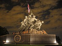
23日午前10時15分、第5海兵師団は遂に摺鉢山頂上へ到達し、付近で拾った鉄パイプを旗竿代わりに、28in.×54in.の星条旗を掲揚した。硫黄島攻略部隊に同行していたジェームズ・フォレスタル海軍長官は、前線視察のため上陸した海岸でこの光景を目撃し、傍らにいたホーランド・スミス海兵中将へ「これで(創設以来、アメリカ軍部内で常にその存在意義が問われ続けてきた)海兵隊も500年は安泰だな。」[20]と語り、この旗を記念品として保存するように所望した。 そこで、揚陸艇の乗員が提供した5ft×8ftと先の旗の2倍となる星条旗を改めて掲げ、先の旗と入れ換えることになった。午後12時15分にAP通信の写真家・ジョー・ローゼンタールが、まさに「敵の重要地点を奪った海兵隊員達が戦闘の最中に危険を顧みず国旗を掲げた」その瞬間を捉えたような印象を与える(つまり後撮り)写真とあわせ写真3枚を撮影した。この写真は同年ピューリッツァー賞(写真部門)を受賞している(『硫黄島の星条旗』、"Raising the Flag on Iwo Jima")。硫黄島の戦いは「アメリカ海兵隊は水陸両用作戦のプロである」という存在意義を広く世界へ向けて示したのだった。しかしその4日後のサンフランシスコでは「(タラワ、サイパン、硫黄島での損害の大きさに)マッカーサーの指揮した戦闘では、このような損害は一度も出ていない」と海軍批判の社説が掲載された。
^「硫黄島」の呼称は、戦前から「いおうとう」「いおうじま」の2種類が混在しており、日本軍は主に「いおうとう」を使用していた。2007年6月18日以降は「いおうとう」が国土地理院の正式な地形図での表記となった。アメリカ軍による「Iwo Jima」の呼称は旧海軍作製の海図のローマ字表記に基づくと考えられる。アメリカは今後も「Iwo Jima」の表記を歴史的理由で維持するという。出典:小笠原諸島地名事典 Place Names
^Joint Chiefs of Staff 713/18, "Future Operations in the Pacific", 2 October 1944.
Alexander, Col. Joseph H., USMC (Ret). Closing In: Marines in the Seizure of Iwo Jima, Marines in World War II Commemorative Series, History and Museums Division, United States Marine Corps, 1994.(米国公刊戦史)
Bartley, Lt.Col. Whitman S., USMC. Iwo Jima: Amphibious Epic, Marines in World War II Historical Monograph, Historical Section, Division of Public Information, United States Marine Corps, 1954.(米国公刊戦史)
In addition, Tranpedia is simply not responsible for any show is only by translating the writings of foreign licenses that are compatible with CC-BY-SA license information.